| Place Names |
Parish |
|
Information |
|
Ballynabragget |
Donaghcloney |
20: 11/52 |
a townland 4km SW of Donaghcloney
town; 390 acres; click
here to see its location on a townland map; means
' townland of the gorge'; held by Art Magennis in 1609; proprietor was the
Marquis of Downshire in 1836; Donaghcloney Presbyterian church here |
V12 p 59 OSM; V 19 MIs;
GIC; PNNI V6 p 87, 88 |
| Ballynacraig |
Inch |
21: 48/50 |
a townland
4km N of Downpatrick; 511 acres; means' rocky town';
site of an ancient church here; owned by Earl of
Ardglass in 1669 & leased by Col. Vere Essex Cronwall; owned by the
Southwell estate in 1752 & leased to Robert Maxwell Esq,; school
here in 1836; Church of Ireland here; click
here to see its location on a townland map; prorietor c. 1830s
was J.W. Maxwell Esq; lead mine 8 Apr 1837 |
LM 1985 p52;
LR 2009 p51; V17 p 73 OSM :GIC; TCC p33; LM 1991 p25; O'L V1 p 327; LM 1988
p22; DR |
| Ballynacraig |
Newry |
. |
most of Newry town is
in this townland ; 682 acres; click
here to see its location on a townland map; means 'townland of
the crags'; belonged to Newry Abbey in 1157 |
PNNI V6 p 9; DDPP p2 |
| Ballynacross |
Annaclone |
. |
see under Ballynagross |
. |
| Ballynadrone |
Magheralin |
. |
a townland
of 111 acres; just east of Magheralin village; Church of Ireland here; click
here to see its location on a townland map; means' townland between
two rivers'; owned by Bishops of Dromore |
V19 MIs; GIPR ; PNNI V6 p 227
|
| Ballynafeigh |
Belfast |
. |
a townland; separation
from Co. Down 27 Jul 1867; near Ormeau Bridge, Knockbreda; St. Jude's Church
of Ireland here ,built 1873 |
DR; RWN p 79 |
| Ballynafern |
Annaclone |
29: 17/39 |
see under Ballinafern;
click here
to see its location on a townland map; means ' townland of the alder tree';
|
V12 p 15 OSM; PNNI V6 p
65 |
Ballynafoy
Ballynefeigh |
Annaclone |
20: 15/60 |
see under Ballinafoy |
V12 p 16 OSM |
| Ballynafoy |
Knockbreda |
. |
a townland of 821 acres;
part of Belfast |
. |
Ballynagallagh
Ballynagalliagh |
Bright |
21: 49/37 |
a townland
4km NW of Killough; click
here to see its location on a townland map; means ' townland
of the foreigners' because of its proximity to Minerstown & the influx
of miners; also named Nunstown because of an ancient graveyard; proprietor
Major Beauclerk in 1836 |
V17 p34, 35
OSM; O'L V1 p 151; Inv 2001 p 9 |
Ballynagappag Ballynagappoge
Ballynagapog |
Clonduff |
. |
a townland of 488 acres
;between Rathfriland and Lough Island Reavy;click
here to see its location on a townland map; means "townland
of the dock weeds"; owned by Rory Magennis c. 1609; sectarian Battle
of Ballynagapog c. 1792; school established 1825, rebuilt 6 Jan 1900; Presbyterian
church here; land held by Marquis of Downshire in 1863 |
O'L V1 p 43; V3 p 4 &
V12 p 101 OSM ; GIC; DR; PNNI V3 p 80; DDPP p113; GV ; TC |
Ballynagarrick
Upper & Lower |
Drumbo |
20: 35/64 |
a townland of 964 acres;
3km SW of Carryduff; click
here to see its location on a townland map; the proprietors in
1833 were Mr Mussenden of Larchfield whose agent was Rev. E.J. Cordner &
the Shaw family & Mr. Morrow & Mr. B. Edwards, attorney of Belfast;
48 landholders; rent from 25-30 shillings an acre; turf bog; in 1833 there
were 105 houses & families; 63 families were employed in agriculture
& 27 in trade or manufacture;265 males & 304 females; 2 professionals
& 25 servants; Presbyterian church in Upper |
V7 p 59, 62 OSM; GIC
|
| Ballynagarrick |
Saul - a detached townland
|
21: 57/45 |
a townland 5km S of Strangford
town; 222 acres; click
here to see its location on a townland map; means ' townland
of the rocks'; old Mass stations of Parcanarry & Craigarory here; owned
by Lord Bangor & C. Leslie Esq. In 1836; rocky dry soil; 1 smithies;
festivities by farmers 10 Feb 1849; Ballynagarrick House here |
V17 p 114, 115 OSM; DR;
Inv 2000 p 23 & 2001 p 10, 25 |
| Ballynagarrick |
Tullylish |
. |
a townland
4km N of Gilford & Tullylish villages; click
here to see its location on a townland map; 862 acres; means
' townland of the rocks';originally belonged to Magennis clan in 1609; Presbyterian
church here; corn mill near Clare bog; proprietor Earl of Clanwilliam &
A. R. Stewart Esq. of Donegal in 1836 ; school here in 1836 |
V12 p 141,142,
143, 144 OSM; PNNI V6 p 332 |
| Ballynagarrick House |
Tullylish ? |
. |
residence of Wright Babe in 1869 |
PPNZ |
| Ballynagee |
Bangor |
. |
alternate spelling for Ballymagee
townland in 1659 |
SP |
| Ballynagelbegge |
Down |
. |
also called
Ballykilbeg; land seizure 1625 |
MID p 34 |
| Ballynagelty |
Kilbroney |
. |
in the Rostrevor
mountains;2km N of Carlingford Lough; woods |
V3 p6, 28 OSM;
CM |
| Ballynagowne |
Ballywalter |
. |
ancient name
for Springvale townland |
SP |
| Ballynagross |
Annaclone |
29: 14/39 |
a townland 4km SW of Annaclone
village;368 acres; click
here to see its location on a townland map; means ' townland
of the crosses'; in 17th century it was part of Shankill; estate of General
Meade in 1836 |
V12 p 16 OSM; PNNI V6 p
67 |
|
Ballynagross
Upper & Lower
|
Ballee |
. |
a townland
5km W of Dunsfort village; 285 & 295 acres; click
here to see its location on a townland map; owned by Earl of
Ardglass in 1669 & leased by Rev. Robert Echlin (Irish) & Patrick
McMolyne (English part) ; part sold to Adam McCutcheon in 1710 then Rev.
A. Walsh in 1718 then Hugh Henry then Joshua MsGeough in 1813; & part
to Downshire Estate in 1710 then Rev. Thomas Nevin then leased to Mr. Johnston;
Irish part owned by Southwell Estate in 1752; owned by Lord De Clifford;
proprietor Mr Bond McGeogh, Armagh & Trinity College in 1836 ; there
were 22 families needing famine relief in these townlands Aug 1847; waylaying
incident 4 Dec
1852; article on townland 2 Jan 1869 |
LM 1985 p52,53;
V17 p 22 OSM; DR; O'L V1 p 307; LM 1991 p25; FCD S2 p 25 |
| Ballynagunikan Ballynagunaghan
|
Donaghcloney |
. |
alternate spelling for Ballygunaghan |
. |
| Ballynahatten |
Kilkeel |
. |
a townland of 333 acres;
click here
to see its location on a townland map; means townland of the gorse'; owned
by the Abbey of Newry in 1157; part of the Bangenal Estate in 1552 &
owned by Lord Nicholas Bagenal in 1690s |
PNNI V3 p 10, 26 ; J,LSG 2010
p15; MO 5/8/ 2009 p6
|
| Ballynahatty |
Drumbo |
20: 32/69 |
a townland of 257 acres;
banks of river Lagan south of Belfast; click
here to see its location on a townland map; the village of Milltown
is in this townland; there is a circular Giant's Ring with a diameter of
222m on the top of a hill & a cromlech in the centre; a place of defence
in ancient times; the proprietor in 1833 was Lord Dungannon whose agent
was Capt Skinner of Belfast; 7 landholders; very good quality land; a flour
mill, a log wood mill,a beetling mill in 1833; in 1833 there were 37 houses;
18 families were employed in agriculture & 10 in trade or manufacture;
873 males & 103 females; 8 servants; |
V7 p 57, 59, 62 OSM : HMNI
p 89;
|
| Ballynahinch |
Magheradrool |
. |
a market town
& a townland of 775 acres; the town is in Ballymaglave North townland;
means 'townland of the river meadow'; click
here for a map of the town in 1782;click
here for a photo
and more information; click
here for a history of Ballynahinch |
. |
| Ballynahinch Junction |
Kilmore |
21: 41/55 |
old disused railway station,
in Ballydyan townland; click
here to see its location on a map |
NWAG p 37 map
|
| Ballynairy |
Saul |
. |
or Ballyverebay; ancient
townland in 17th century in East Down; most possibly Ballynarry |
V17 p 123 OSM |
| Ballynamagna |
Drumballyroney |
29: 17/36 |
a townland 3km NW of Rathfriland;
676 acres; click
here to see its location on a townland map; means ' townland
of the O'Beggans'; held by Sir Art Magennis in 1609; ancient silver coins
found before 1836; corn & flax mill; proprietor General Meade in 1836;
old rents from 2- 12 shillings an acre; new rents 27-35 shillings an acre;
largest farm 53 acres |
V3 p 12, 16, 18 OSM; PNNI
V6 p 158 |
| Ballynamoney |
Kilbroney
|
. |
alternate spelling for Ballymoney townland on
Rent Roll of 1692 |
PNNI V1 p 141 |
| Ballynanagh |
Clonduff
|
. |
alternate name for Ballynanny townland
in 1659 census |
V17 p 123 OSM;
SP |
| Ballynanemore |
. |
. |
ancient townland in 17th
century in East Down |
V17 p 123 OSM |
| Ballynanery |
. |
. |
or Ballygaireige;
Ancient townland in 17th century in East Down |
V17 p 123 OSM |
Ballynanny
Ballynany |
Annaclone |
20: 14/42 |
a townland 5km SE of Banbridge;
538 acres; click
here to see its location on a townland map; means ' routeway
of the marsh'; its ancient name was Baile Chaisil (Comgall's Castle); bog
here ; proprietor Mr Jones Esq. In 1836; Presbyterian church here |
V12 14, 16 OSM; DDPP p104;
GIC; PNNI V6 p 67 |
| Ballynannay Ballynanny
|
Clonduff |
29: 24/28 |
a townland in the foothills
of the Mournes near Hen Mountain ; 3km SE of Hilltown; 1698 acres; click
here to see its location on a townland map; means " townland
of the uncut bog or marsh "; the ancient 7th century monastery of Ballycommogue
was in this townland (an offshoot of Bangor Abbey) ; its 1st Abbot was St.
Mochommoc who died AD655; held by Ever Magennis in 1609 then the Bishops
of Dromore by 1611 then the tenants claimed tenant rights & the King
granted them leases forever; owned by Mary Mathews in 1641 then passed to
her agent William Waring who sold 4 townlands (Ballyaughian, Ballymaghery,
Ballynanny & Leitrim) to Narcissus Barr Esq. for £33,000 who evicted
tenants who couldn't pay their rents ; proprietor was Narcissus Batt Esq.
in 1834 & Robert Batt in 1863; Ballynanny House here; farms sold to
the tenant farmers in 1912 |
GAA CS p 19;TC; AR p 3; PNNI V3
p 69, 71, 81, 106; GV; DDPP p104,105 ; TC p15,26
|
| Ballynanny House |
Clonduff |
. |
residence of the influential Hall
family |
TC p15 |
| Ballynaris |
Dromore |
20: 19/54 |
a townland 1 km NW of Dromore;986
acres; click
here to see its location on a townland map; means ' townland
of the building'; Palace of Lord Bishop of Dromore in 1836; church lands
until 1868 |
V12 p 76 OSM; PNNI V6 p
114 |
| Ballynarry |
Saul - a detached townland |
. |
a townland 5km SE of Downpatrick;
click here
to see its location on a townland map; means ' townland of the forth' ;
in Feb 1646, James Audley junior sold townland to Bernard Ward; in 1177
English settlers used the ancient raths or forts; site of an ancient Catholic
chapel; Lord Bangor owner in 1836 ; part rocky-part clay; game of hurley
played here 1830s; story
about growing up in Ballynarry |
V17 p114 OSM; Lm 1986 p6;
LWAG p 2; Inv 1997 p 29 & 2001 p 10 & 2002 p 15; O'L V1 p p204,
211 |
| Ballynarry House |
Saul |
. |
residence of Robert Greer Esq. in 1863 |
Limerick Chronicle |
| Ballynaskeagh |
Aghaderg |
. |
a townland 5km SE of Loughbrickland;
665 acres; click
here to see its location on a townland map; means ' townland
of the thorn bushes';part of the old district of Shankill;paid tithes to
Catholic church in 1615; held by Sir Hugh Montgomery in 1615; the proprietot
og ballinaskea Hill in 1795 was James Todd; Ballynaskeagh House here |
V12 p 1 OSM; old b/w map
E8; PNNI V6 p 25; UHA; O'L B p319, 326 |
| Ballynaskeagh Cross Roads |
Aghaderg |
29: 14/38 |
5km SE of Loughbrickland |
. |
| Ballynaskeagh |
Newtownards |
. |
alternate spelling for Ballyskeagh townland in
1664 |
PNNI V2 p 224
|
| Ballynavally |
Drumbo |
. |
a townland just N of Purdysburn
town; 298 acres; click
here to see its location on a townland map; contains Shaw's Bridge
over the River Lagan; in 1833 there was a corn mill & a flax mill; the
proprietor in 1833 was Mr P Dunlop whose agent was Mr W. Malcom of Hillhall;
farmed by the proprietor; very good quality land; 1 corn mill & 1 wood
log mill in 1833; there were 68 houses; 27 families were employed in agriculture
& 13 in trade or manufacture; 141 males & 169 females; 3 professionals;
13 servants; Methodist church here |
V7 p 54, 56, 60 ,62 OSM ; GIC
|
| Ballyndooalty |
Kilbroney
|
. |
alternate spelling for Ballindoalty townland
in 1732 |
PNNI V1 p 136 |
| Ballyneboyle |
Greyabbey
|
. |
alternate name for Ballyboley
townland in 1627 |
V17 p 123 OSM; PNNI V2
p 201 |
| Ballynecreeire |
Comber |
. |
ancient townland
in 17th century in East Down; could be Ballycreelly |
V17 p 123 OSM |
| Ballynecross |
Annaclone |
. |
spelling for Ballynagross townland in Rent Roll
of 1692 |
PNNI V6 p 67 |
| Ballynecross |
Magheralin |
. |
alternate spelling for Ballycross townland in
1661 |
PNNI V6 p 259 |
| Ballyneddan |
Kilbroney |
29: 20/15 |
a townland
near Carlingford Lough, 3km SE of Rostrevor;129 acres; click
here to see its location on a townland map; means ' townland
of the stream'; originally belonged to Donald & James McYawn then Nicholas
Bagnall in 1585; proprietor David Ross Esq. in 1836 |
V3 p 28, 31
OSM; CM; PNNI V1 p 142 |
| Ballyneddan Upper |
Kilbroney |
. |
a townland of 117
acres; click
here to see its location on a townland map |
. |
| Ballynefeigh |
Annaclone |
. |
spelling of Ballinafoy in Rent Roll
of 1692 |
PNNI V6 p 66 |
| Ballynegallbegge |
Down |
. |
alternate name for Ballykilbeg townland
in 1586 |
O'L B p 583 |
| Ballynegardis |
Newtownards |
. |
alternate name for Tullynagardy townland
in 1830 |
PNNI V2 p 236 |
| Ballyneghee |
Bangor |
. |
alternate name
in 1659 Census for Ballymagee |
TU p 107; PNNI
V2 p 157 |
| Ballynekelly |
Seapatrick |
. |
alternate spelling for Ballykelly townland |
PNNI V6 p 308 |
Ballynemagenagh
Ballynemognagh |
Drumballyroney |
. |
spelling for Ballynamagna townland on Rent Roll
of 1692 & 1659 Census |
PNNI V6 p 158 |
| Ballynemagheriawly |
Magherally |
. |
ancient name for Magherally |
V12 p 112 OSM |
| Ballynemaghery |
Clonduff
|
. |
alternate spelling for Ballymaghery townland
in Subsidy Roll of 1662 |
PNNI V3 p 80 |
| Ballynemary |
. |
. |
ancient townland in 17th
century in East Down |
V17 p 123 OSM |
| Ballynemoney |
Donaghadee & Kilcoo
|
. |
alternate spelling for
Ballymoney townland in 1636 & 1659 |
V17 p 123 OSM; PNNI V2
p 185 & V3 p 106 |
| Ballynenullan |
Greyabbey
|
. |
alternate spelling for
Ballyurnanellan townland in 1627 |
V17 p 123 OSM; PNNI V2
p 205 |
| Ballynercreagh |
Inch |
. |
or Ballycanenreagh; Ancient
townland in 17th century in East Down; possibly Ballynacraig |
V17 p 123 OSM |
| Ballynercrosse |
Ballee |
. |
ancient townland in 17th
century in East Down; possibly Ballynagross |
V17 p 123 OSM |
| Ballyneross |
Dromore
|
. |
spelling for Ballynaris townland in a will of
1763 |
PNNI V6 p 115 |
| Ballyneshatny |
Kilkeel
|
. |
alternate spelling for Ballynahatten
townland in Subsidy Roll of 1663 |
PNNI V3 p 27 |
| Ballynescore |
Greyabbey
|
. |
alternate spelling
for Ballynester townland |
V17 p 123 OSM;
PNNI V2 p 204 |
| Ballynessian-tragh |
Grey Abbey |
. |
or Ballyblack; Ancient
townland in 17th century in East Down |
V17 p 123 OSM |
|
Ballynester Ballynestor
|
Grey Abbey |
21: 58/69 |
a townland
1km N of Grey Abbey; 191 acres; click
here to see its location on a townland map; has an area of bog;
means' townland of the doorkeeper'; the proprietor in 1795 was Rev. Henry
Dillon |
V17 p 123 &
V7 p 67 OSM; PNNI V2 p 204; UJA |
| Ballyneva |
Grey Abbey |
. |
ancient townland in 17th
century in East Down; most probably Ballynova |
V17 p 123 OSM |
| Ballynevary |
. |
. |
or Ballynemary- an ancient
townland in 17th century in East Down |
V17 p 123 OSM |
Ballynewport
Ballynybert |
Rathmullan |
. |
a townland 5km NW of Killough;
287 acres; click
here to see its location on a townland map; originally in the
Catholic parish of Down; proprietor was Brett family c. 1786 then Mr Hamilton
in 1836 |
O'L B p 523; V17 p 35 OSM;
old b/w map M15; LM 1983 V1 p13; LM 1999 p89 |
Ballynichol
Ballynicholl |
Ballytrustan |
. |
a townland 1km W of Portaferry
town; 201 acres; click
here to see its location on a townland map; means
' Nichol's townland'; granted to Patrick Savage in 1559; in 1659
there were 6 Scots/English & 2 Catholic families here;
lowest rent in 1836 was 30 shillings & the highest £3.3.0; proprietor
was Mr. Nugent; part of this townland was Town Parks |
V7 p 7 OSM; MSGIIG p13; SP; PNNI
V2 p59
|
|
Ballynichol
Ballynickle
|
Comber |
21: 45/68 |
a townland 2km S of Comber
; 289 acres; click
here to see its location on a townland map; the proprietor in
1837 was Mr. Johnston of Belfast;land quality middling; old leases at 14
shillings an acre; size of farms 10-70 acres; rent 30-40 shillings an acre
in 1837; 40 males & 49 females in 1837; ancient stones called The Altar,
5 stones, 6 feet high & Five Sisters here ; railway line here in 1863 |
V7 p 37, 40, 42 ,44 OSM ; old
b/w map R8;TOOC p17; GV
|
| Ballynichol House |
Comber |
. |
house & farm of 52 acres in Ballynichol townard,
leased by William Boyd in 1863 from Sir Willia. G. Johnson |
GV
|
| Ballynigillgall |
Clonallan
|
. |
alternate name for Ballyvally townland on Rent
Roll of 1692 |
PNNI V1 p 64 |
| Ballynisure |
. |
. |
ancient townland in 17th
century in East Down |
V17 p 122 OSM |
| Ballynock |
Moira |
20: 19/57 |
alternate spelling for Ballyknock
townland |
V12 p118, 120
OSM |
| Ballynockan |
Saintfield |
. |
alternate spelling for Ballyknockan
townland |
POD |
| Ballynoe |
Bright |
21: 48/40 |
a townland
4km S of Downpatrick; click
here to see its location on a townland map ;
Druidical ring here; owned by
the Soythwell Estate in 1752; assigned to Capt. William Hamilton by James
Shane c. 1767; bought by Ker family in 1835; proprietors heirs of Lord De
Clifford in 1836 ; school here in 1836; deeds & leases 1790-1819 in
PRONI; railway station site |
LM 1985 p7;
V17 p33,36 OSM; LM 1991 p27; OFD p192; NWAG p37 map; HMNI88; DR*
3/12/03 ; LM 1998 p96; LM 2000 p44-61 (archaeology) |
| Ballynoe |
Donaghadee |
. |
a townland 1km W of Donaghadee
town; 187 acres; click
here to see its location on a townland map ; means ' new town'
being a new settlement built near Donaghadee town in 1605; in 1659 there
were 0 English/Scots & 5 Catholic families here; owned by Daniel Delacherois
in 1863 |
V17 p 124 OSM; PNNI V2
p 185;SP; GV |
| Ballynoris |
Dromore |
. |
spelling for Ballynaris townland in 1659 Census |
PNNI V6 p 115 |
| Ballynova |
Grey Abbey |
. |
land & tithes granted
to Hugh Montgomerie in 1626 by King Charles 1st |
V17 p 133 OSM |
| Ballynreacy |
Inch |
. |
residence of Martin family
in 1768 |
MID p 91 |
| Ballynteir |
Clonduff |
. |
an ancient townland c. 1659; could
be Ballintur |
PNNI V3 p 100 |
|
Ballyobegan Ballyobigan
Ballyobikin
|
Inishargy |
21:62/66 |
a townland
3km S of Ballywalter town; 564 acres; click
here to see its location on a townland map; means ' Hopkin's
townland' ; in 1659 there were 13 Scots/English & 4 Catholic families
here & the proprietor was James Wallace Esq.; coastguards house here
in 1863 |
V17 p 125 &
V7 p 85 OSM;SP; PNNI V2 p 87;GV |
Ballyobegan House
Ballyobecan House |
Inishargy |
21:
62/66 |
house & farm of 51
acres; 1km from the shore , 3km S of Ballywalter town; residence of Alexander
Allen Esq. in 1834; described as spacious & rather handsome house but
looks bare without any planting around it ; held in fee by Robert Allen
in 1863 & residence of William Gibson in 1886 & James A. Gibson
in 1910 |
V7 p85 OSM ; PNNI V2 p 88;
GV ; POD
|
| Ballyobenden |
. |
. |
ancient townland in 17th
century in East Down; possibly Ballobegan |
V17 p 123 OSM |
| Ballyoghley |
Saintfield |
. |
means ' place of the young warriors; ancient name for
Oughly townland
|
O'L V1 p 375 & 3766
|
Ballyoran
Ballyorran |
Dundonald |
. |
a townland 3km E of Dundonald
town; 228 acres;click
here to see its location on a townland map;
means ' place of the cold spring'; in 1659 there were 2 English/Scots &
3 Irish families; proprietor in 18th century was Lambert family; 1 corn
mill in 1837; the proprietor in 1837 was Councillor Craig of Lisburn; good
land; farms from 10-56 acres; rent £2 an acre; public works program
instigated for famine relief with road upgrade from Ballyoran to
Churchquarter in 27 May 1848 |
V7 p 40, 65 OSM ; TMUOP p75,
90, 231; FCD S2 p 8
|
| Ballyoran House |
Dundonald |
.
|
in Ballyoran
townland; built in 1878 by McRoberts family |
TMUOPS p 145
|
| Ballyorgan |
Rathmullan |
. |
a detached
townland of 319 acres; click
here to see its location on a townland map;
means ' O'Horgan's townland' site of an ancient church here called Chapel
NaCoole ; originally owned by Bangor Abbey in 1615; held by Sir Robert Ward
in 1670; bought by James Cumine c. 1720; windmill for corn here in 1836 |
V17 p 67,108
OSM; Inv 2013 p5; O'L V1 p 201, 307, 325 & B p 140, 322; Inv 2001 p
36;LR 2003 p 44; LM 1985 p3; LR 2011 p9 |
| Ballyorgan House |
Rathmullan |
. |
built by James Cumine before 1755; described
as a 2 storey mansion house with sitting room on each side of the hall door
and 5 windows above and and orchard; only the pigeon house remained by 1850 |
LM 1985 p3; LM 1996 p28
|
| Ballyoudan |
Kilclief |
. |
ancient name for Ballywoodan townland |
O'L V1 p 203
|
| Ballyowen House |
Drumbo |
20: 31/67 |
farm; on the S bank of
river Lagan S of Belfast; formerly Ballygowan House & owned by the Johnson
family |
PE
|
| Ballyphilip |
Ballyphilip |
. |
a townland
& a parish on the entrance to Strangford Lough ; the town of Portaferry
is near this parish; 180 acres;click
here to see its location on a townland map;
means ' Philip's townland'; the proprietor in 1795 was the Rector of Diocese
of Down; parish boundaries changed 12 Jan 1828; lowest rent in 1836 was
35 shillings & highest was £3.3.0; proprietor was Mr. Nugent;
part of Town Parks is in this townland; school here |
NCT; V7 p 7 OSM; O'L B p 328; IJA;PNNI
V2 p 41
|
|
Ballyplant
Ballypaunt
Ballyplunt
Ballyplont
|
Rathmullan |
21:46/38
|
a townland
6km SW of Downpatrick; 375 acres; click
here to see its location on a townland map; owned by Alderman
Hutchinson c. 1641 then William Hamilton; proprietor Colonel Ward with his
authority William McMullen in 1836; lead mine 8 Apr 1837 |
LR 2006 p18;
V17 p 35, 37 OSM;LM 1988 p22 ; LM 1999 p88; DR; LM 2000 p88 |
| Ballyquillan |
Newtownards |
. |
townland in
1659 ;there were 6 English/Scots & 2 Catholic families here; |
SP |
|
Ballyquentin
Ballyquinton
Ballyquintine
|
Ballyphilip or
Witter
|
. |
a townland
4km SE of Portaferry, on the southern most tip of Ards Peninsula; click
here to see its location on a townland map; in 1659 there were
12 Scots/English & 19 Catholic families here & the proprietors were
Robert Maxwell & his son, Colin; proprietor Rev
Mr Blacker of Markethill & Mr Nugent in 1836: rents in 1836 were between
9 shillings & 25 shillings with highest rent at 35 shillings; sale of
wreck 3 Aug 1844; shipping casualty steamer 'Dunmore' stranded 27 Aug 1881;
shipwreck 'SS Ayreshire' 11 Apr 1885 |
V7 p 7, 125
& V17 p 125, 127 OSM; DR; PNNI V2 p 127; SP ; DS 1998 p58 |
| Ballyquinton Point |
Ballyphilip |
21: 62/45 |
southern most tip of the
Ards Peninsula in the Irish Sea |
V7 p 9 OSM
|
| Ballyraer |
Donaghadee |
. |
alternate spelling for Ballyrawer
townland in 1659 census |
PNNI V2 p 186
|
| Ballyrainey |
Dundonald |
21: 44/72 |
a townland 5km SE of Dundonald;
445 acres; click
here to see its location on a townland map; means ' place of
the point'; owned by Clannaboy O'Neills before 1600;Bronze Age pottery found
here & ancient fairy ring; in 1659 there were
4 English/Scots & 8 Irish families; the proprietor in 1795 was David
Jameson; 1 flax mill in 1837;there was a flax mill in 1836;
the proprietor in 1837 was Mr Houston, a banker from Belfast; very good
land; farms from 5-40 acres; rent 25- 40 shillings an acre; old leases 10
shillings; crops oats,potatoes, wheat, oats, some flaX,;railway here in
1863 |
UJA; V7 p 41 ,65 ,110 OSM ;
TMUOP p28, 43,65, 75, 231 ;GV
|
| Ballyrainey House |
Dundonald |
. |
house & farm of 74 acres; residence
of Freeman Hardy in 1852; leased by Samuel Carson in 1863 from Mary Bkaiston-Houston
|
POD; GV; old b/w map S7
|
| Ballyraphere |
. |
. |
ancient townland in 17th
century in East Down |
V17 p 123 OSM |
| Ballyrange |
Down |
. |
see Ballyvange
|
TAB |
| Ballyrann |
Kilkeel |
. |
alternate spelling for Ballinran townland in 1659 census
|
SP |
| Ballyrare |
Donaghadee |
. |
alternate spelling for Ballyrawer
townland in 1833
|
V17 p 124 OSM; PNNI V2
p 186 |
| Ballyrassell |
Bangor |
. |
mill dam of 123 acres in
1836 |
V7 p 19 OSM
|
| Ballyrawer |
Donaghadee |
21: 58/73 |
Carrowdore Castle is in
this townland; 7km S of Donaghadee; 336 acres;means ' a thick townland';
click
here to see its location on a townland map; contains
a small pond & a spring impregnated with iron; in 1659 there were 8
Scots/ English & 1 Catholic families here; a Church of Ireland &
Presbyterian churches here ; the proprietor in 1795 was Samul D, Crumlin;
owned by Nicholas D. Crommelin in 1863 |
V7 p 45, 49 OSM; SP; GIC ;
PNNI V2 p 186; UJA;GV
|
| Ballyreagh |
Dromore |
. |
alternate name for Magherabeg townland
in 1609 |
PNNI V6 p 138 |
|
Ballyrea
Ballyreagh
Ballyree
|
Newtownards
|
21: 51/73 |
a townland
2km SE of Newtownards; 333 acres ; click
here to see its location on a townland map; means 'townland of
the ram'; in 1659 there were 4 English/Scots & 6 Catholic families
here; the proprietor in 1836 was Lord Londonderry
& in 1863 the Marquis of Londonderry ; fire on Shore Rd, Alex Paton's
9 Nov 1889 |
V17 p 123 &
V7 p 111, 113 OSM; SP; NC; PNNI V2 p 223 ;GV |
|
Ballyrea
Ballyree
Ballyray
|
Bangor |
. |
a townland
of 233 acres & 2 acres of marsh; click
here to see its location on a townland map; means' townland of
the heather'; in 1659 there were 4 English/Scots & 3 Catholic
families here; 200 acres belonging to Mr. Hugh White
for sale 22 Oct 1795 |
V7 p 19 &
V17 p124 OSM; SP; NS; PNNI V2 p 159 |
| Ballyregan |
Dundonald |
15:41/75
|
a townland which contains
the village of Dundonald; 522 acres;click
here to see its location on a townland map;
means ' O'Regan's place'; in 1659 there were 7 English/Scots & 2 Irish
families; the proprietors in 1837 were J. Ross of Ballyalloly & Mr Jackson
of Ballybay. good quality land; farms from 8-40 acres; rents were 35 shillings
an acre in 1837; Church of Ireland & Presbyterian Meeting House, school
established 1829; |
V7 p 41 ,64, 65 OSM; TMUOP p75,
231
|
| Ballyregan |
Saul |
. |
a clachan in Ringbane townland |
PE |
|
Ballyreanew Ballyrenan
|
Ballee |
21:54/45
|
a townland
5km E of Downpatrick near Lough Money; 604 acres;
click here to see its location on a townland
map; the proprietor in 1795 was William Stockdale; owned by heirs of Lord
De Clifford & Lord Bangor in 1836 |
UJA;V17 p 20,
21 22 OSM |
| Ballyreig |
Kilkeel |
. |
alternate name for Ballyveagh townland in Subsidy
Roll of 1663 |
PNNI V3 p 28 |
Ballyrenan
Ballyrenald |
Inch |
21: 47/47 |
a townland of 604 acres
2km NW of Downpatrick; click
here to see its location on a townland map;derived
from Bally Regnall meaning townland of Ragnal/ Reynold l (a Viking name);
ancient woodland here; originally owned by
Inch Abbey; owned by Earl of Ardglass & leased to John Echlin Esq. 1637-
1698 ; new roads at Stranaghans hill 29 May 1852; melancholy suicide 29
Jun 1878 |
V17 p 73 OSM; LM 1985 p53;
LM 1999 p36; DR; TCC p33; O'L V1 p 325l LR 2009 p51 |
|
Ballyrichard
Ballyrickard
Ballyregart
|
Comber |
. |
a townland
3km NE of Comber; 397 acres; click
here to see its location on a townland map; ancient church here
before 1622; paid tithes to Catholic church in 1615; land & tithes granted
to Hugh Montgomerie in 1626 by King Charles 1st; proprietor in 1837 was
the Marquis of Londonderry whose agent was Mr Andrews of Comber;very good
land; farms from 10-50 acres;rent 21-38 shillings an acre;49 males &
49 females in 1837; railway here in 1863;melancholy
suicide near Comber 12 Jun 1886 |
V17 p 73 &
V7 p 37, 39, 42 OSM; TOOC p24; GV; DR; O'L B p 326, 327 |
Ballyridley
Ballyriddelly |
Ardquin |
. |
a townland
on the shores of Lough Cowey; 236 acres; click
here to see its location on a townland map; means ' Ridels' townland';
in 1659 there were 6 English/Scots & 0 Catholic
families here; Tenant Rights meeting 12 Feb 1881 |
V17 p 125 &
V7 p 4 OSM; DR;SP; PNNI V2 p 32 |
| Ballyroastee |
Ballyphilip |
. |
ancient townland in 17th
century in East Down; possibly Ballyrusley |
V17 p 123 OSM |
| Ballyrobert |
Holywood |
15:44/82
|
a townland of 460 acres;
on the shore near Helen's Bay;click
here to see its location on a townland map ; a school established
in 1820; the proprietor in 1834 was H. Kennedy Esq. whose agent was Mr Crawford
of Ballycultra; there were 30 houses; 21 families employed in agriculture
& 1 in trade; 80 males & 84 females; 1 capitalist; 17 servants;
Gospel Temperance Meeting 24 Mar 1894 |
V7 p 76 ,77, 78 OSM ; GV; BM;
NC
|
| Ballyrogan |
Kilkeel |
. |
also called Mourne Park
townland; 1141 acres;3km NW of Kilkeel;click
here to see its location on a townland map; means ' O'Rogan's
townland'; part of the Bagenal Estate in 1552 & owned by Lord Nicholas
Bagenal in 1690s ; 8 Irish people living here in 1659, the owner was Richard
Houston Esq.; |
CM ; SP ; MO 5/8/2009 p6;
PNNI V3 p 10, 27
|
| Ballyrogan Ballyroghan
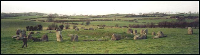
|
Newtownards |
15:46/74 |
a townland 3km NW of Newtownards;
363 acres ; click
here to see its location on a townland map; means ' O'Rogan's
townland; owned by Clannaboy O'Neills before 1600;
in 1659 there were 2 English/Scots & 2 Catholic families here;there
was a corn mill, a windmill for flax and a National school here in 1836
(& 1863)
|
;V7 p 100 OSM; SP; BM; PNNI V2 p 224; TMUOP p65;GV |
| Ballyrolly |
Down |
21: 43/41 |
a townland 2km NE of Clough
on the Downpatrick road; 310 acres; click
here to see its location on a townland map; means Rolf's or Ralph's
townland'; site of an ancient chapel & crannoge;paid tithes to Nuns
of Down in 1615; in 1625 land seizure, by Robert Swoords; owned by John
W Maxwell Esq. proprietor Mrs. Colt Maxwell, London in 1836; old graveyard
here |
LR 2005 p 22V17 p 52, 55,
57 OSM: MID p 34; GIC; O'L v1 p 305, 306 & B p 327 |
| Ballyrolly |
Donaghadee |
. |
a townland 1km S of Millisle;
253 acres; click
here to see its location on a townland map; site of an ancient
Catholic chapel called Ralftona ; in 1659 there were
6 Scots/ English & 2 Catholic families here; Girls Free Schoolhouse
here in 1863 |
V17 p 124 OSM ; O'L B p
284;SP; PNNI V2 p 177, 186;GV |
| Ballyrolly Burn |
Donaghadee |
21: 58/74 |
near Carrowdore Castle;
7km S of Donaghadee |
. |
| Ballyrolly House |
Donaghadee |
15:60/75 |
farm estate on the coast; 1km S of Millisle |
. |
| Ballyroney |
Drumballyroney |
29: 22/38 |
village and townland of
1241 acres; 4km NNE of Rathfriland; click
here to see its location on a townland map; means 'O'Roney's
townland'; site of ancient earthwork motte & bailey called Castle of
Magh Cobha, destered in favour of Seafin Castle; ancient Mass Rock here;
proprietors J. Byrch Esq. & Mr Prentis of Armagh & J Haddock of
Dublin in 1836; Presbyterian Church here; lake
here ; bridge over River Bann; school next to church; flow bog; largest
farm 35 acres; rents from 18-20 shillings an acre; Mr McReavys farm here
; ancient rath here ; Homicide 5 Mar 1842: riot 21 Mar 1846; Protestant
Association 11 Apr 1868; narrow gauge railway Banbridge to Castlewellen
through Ballyroney 31 Jan 1880 |
V3 p 10, 11, 13, 14 , 15,
16, 18 OSM; DDPP p3, 133; DR; WAG p 37 map; IPP p 110; GIPR; PNNI V6 p 159 |
| Ballyroney Lake |
Drumballyroney |
29: 23/38 |
1km NE of Ballyroney village;
ancient crannog in centre |
PNNI V6 p 179; IPP p 38
|
| Ballyroolley |
Killyleagh |
. |
Moore family
here in 1805; possibly Ballyrolly |
MID p 142 |
| Ballyrosane |
. |
. |
ancient townland in 17th
century in East Down |
V17 p 123 OSM |
| Ballyrosse |
Clonallan |
. |
alternate spelling for Ballyrussell townland
in 1659 census |
PNNI V1 p 63
|
| Ballyrowghroogh |
Ardkeen |
. |
ancient name for Rowreagh townland |
O'L V1 p 426
|
| Ballyrush |
Comber |
. |
a townland 3km SSW of Comber;
539 acres;click
here to see its location on a townland map; v Robert Montgomery;
proprietor in 1837 was the Marquis of Londonderry whose agent was Mr Andrews
of Comber; farms from 15-20 acres; good quality land; rent 20-30 shillings
an acre in 1837;87 males & 85 females in 1837;railway here in 1863 |
UJA;V7 p 37, 39, 42 OSM ;GV
|
| Ballyrush House |
Comber |
21: 43/66 |
house & farm of 97
acres; 3km SSW of Comber ; owned by Marquis of Londonderry in 1863 &
leased by Samuel Kerr; residence of late Robert Kerr in 1873 |
GV ; NLAT
|
| Ballyrushboy |
Knockbreda |
. |
townland of 96 acres ;
now part of Belfast |
. |
|
Ballyrusley Ballyrussley
Ballyrusselly
|
Ballyphilip |
. |
a townland
4km NE of Portaferry town; 231 acres; click
here to see its location on a townland map; means
' Russell's townland'; granted to Patrick Savage in 1559; in 1659
there were 5 Scots/English & 2 Catholic families here;
proprietor Mr Nugent of Ballymurphy in 1836; lowest rent then was 25 shillings
an acre & the highest 35 shillings |
V7 p 7 &
V17 p123, 124, 126 OSM; MSGIIG p13; PNNI V2 p 45; SP |
| Ballyrussell |
Clonallan |
. |
a townland north of Warrenpoint;
278 acres; click
here to see its location on a townland map; means 'Russell's
townland' ;the proprietor 1810- 1891 was Narcissus Batt then his son, Robert
& grandson Robert |
PNNI V1 p 62 ; NR 30/6/2005
p67
|
| Ballyrussell |
Comber |
21: 42/71 |
a townland 4km NW of Comber;
453 acres;click
here to see its location on a townland map; means ' de Rossal's
place'; in 1659 there were 6 English/Scots & 2 Irish families; the proprietor
in 1837 was J. Hammill of Newtownards whose agent was Mr Sinclair of Belfast;
farms from 10-40 acres; rent 20-28 shillings an acre in 1837; land of middling
quality; 68 males & 54 females in 1837; public works program instigated
for famine relief with road upgrade from the bridge to Comber in 27 May
1848 ; railway line here in 1863 |
V7 p3, 40, 42 OSM; TMUOP p75, 232;
FCD S2 p 9 ; GV
|
| Ballyrussell
House |
Comber |
. |
NW of Comber;
residence of James Wood in 1902 |
POD
|
| Ballysallagh |
Ballee |
21: 53/43 |
a townland 4km SE of Downpatrick;
401 acres; click
here to see its location on a townland map; owned by Earl of
Ardglass in 1669 & leased to Sir Robert Ward; east portion lease sold
to William Irwin in 1710 then Provost Baldwin in 1752 ; owned by the Southwell
estate in 1752; leased to John McMeehan in 1772 then James Lang then Mr
Auchinleck;proprietor Mr Crawford, Dublin & Mr Thomson, Dublin in 1836
; western portion leased by Provost Baldwin in 1752 to John Speers who sold
it in 1772 to James Crawford who sold it to John Craig in 1836; there were
19 families needing famine relief here in Aug 1847; article on townland
2 Jan 1869 |
LM 1985 p52; LM 1991 p25;
V17 p 20, 22 OSM; DR; O'L V1 p 307, 308 |
| Ballysallagh Major &
Minor |
Bangor |
. |
a townland of 934 acres;
near Crawfordsburn; 98 acres; click
here to see its location on a townland map; means' dirty townland';
in 1659 there were 28 English/Scots &
13 Catholic families here; the pro[rietor in 1795 was James Savage; uncultivated
land in 1836; a flax mill in 1836; a school in Minor in 1836; new Presbyterian
church 30 Apr 1842 |
V7 p 19, 25 OSM; DR;SP;
BM; PNNI V2 p 160; UJA;FCD S2 p 25 |
| Ballysallagh House |
Bangor |
15:47/79 |
house & farm of 13 acres in Ballysallagh
Minor townland ; 5km SW of Bangor; leased by James Kennedy in 1863 from
Lord dufferin & Claneboye |
GV |
| Ballysallagh Ballysallough |
Dromore |
20: 21/52 |
a townland 2km SE of Dromore;573
acres; click
here to see its location on a townland map; means ' townland
of the herds'; held by William Worsley in 1609; church lands until 1868;
black bog here |
V12 p 70 OSM; PNNI V6 p
116 |
| Ballyscragh |
Aghaderg |
. |
alternate name for Ballynaskeagh
townland |
O'L B p 319 |
| Ballyscrue |
Down |
. |
ancient name for Ballystrew townland
|
LM 1999 p88 |
Ballyshancole
Ballyshanholes |
Aghaderg |
. |
alternate name
for Shankhill townland |
V12 p 3 OSM |
|
Ballysheil or Ballyshell
|
Annaclone |
20: 20/41 |
a townland
7km N of Rathfriland; on banks of the Bann river; 385 acres; click
here to see its location on a townland map; held by O'Sheil family
in 1527; owned by Bishop of Dromore with proprietor J. Ogle Esq. Newry in
1836 |
DDPP p132;
V12 p 16 OSM |
| Ballysherrin |
Down |
. |
ancient name for Lisboy townland |
O'L v1 p 259
|
| Ballysilly |
Saintfield |
. |
a small, shallow lake; pike, trout & eels
caught in it in 1837; also called Ballygilly |
V7 p 117 OSM
|
Ballyskeagh
Ballyskeogh |
Lambeg |
20: 29/67 |
in Co. Antrim; a townland
of 430 acres; 1km W of Drumbeg village; click
here to see its location on a townland map ; in 1659 there
were 14 English/Scots & 4 Catholic families here |
SP; SHM '94 p56
|
Ballyskeagh
Lower & Upper |
Newtownards |
. |
a townland 3km NW of Newtownards;
Upper/ High 669 acres & Lower 372 acres; means ' townland of the hawthorne';
click
here to see its location on a townland map; ancient standing
stone here (photo available); site of an ancient chapel in Chapel Field;
in 1659 there were 11 English/ Scots &
2 Catholic families here;in 1836 there was a windmill for flax &
a National school ; eviction 16 Feb 1889
|
V7 p 110 OSM; NC; SP; PNNI V2 p 224; TMUOP p28,38 |
| Ballyskeagh House |
Newtownards |
15:46/77
|
farm; 3km NW of Newtownards |
. |
| Ballyskelly |
Bangor |
. |
an old townland in 17th century now
part of Ballygrot townland |
PNNI V2 p 145, 176 |
Ballyspurge
Ballyspiuge |
Slanes
|
. |
a townland
2km S of Clogy village, on the coast; 212 acres; click
here to see its location on a townland map; means
' Sporde's townland' after Sprod'es Castle here in 1595; in 1659
there were 7 Scots/English & 4 Catholic families here;proprietor
Mr McNeilly & Mr. Nugent in 1836; kelp; all rents above 22 shillings;in
1837 there was a ruin of a house called Whitehouse built 1640 by Patrick
Savage |
V7 p8,121 &
V17 p 125, 127 OSM; SP; HMNI p114; old b/w map U 16; PNNI V2 p 116 ; LR
2005 p18 |
|
Ballystockard
Ballystockert
|
Comber |
21: 43/71 |
a townland 2km NW of Comber;
628 acres; click
here to see its location on a townland map; means 'place of the
high stook'; click
here for a photo; a flax mill, 2 corn mills & a school in
1837; part proprietors were the Marquis of Londonderry whose agent was Mr
Andrews of Comber & Rev. Cleland;34 landholders in 1837; In Rev Cleland's
part, farms were 10-20 acres; rent was 28-32 shillings an acre; In Lord
Londonderry's part, farm were 15-25 acres; rent per acre 25-28 shillings;
land of middling quality;120 males & 127 females in 1837 ; railway line
here in 1863; "The Haw" auction of valuable farms with scutch
mill 16 Sep 1876 |
V7 p 30, 31, 34 ,35, 37,
40, 42 OSM; TMUOP p232; GV; DR |
| Ballystockard House |
Comber |
21: 43/72 |
farm; 4km NW of Comber |
. |
Ballystokes
Stokestown |
Ballee |
21: 52/46 |
a townland 4km NE of Downpatrick
near Lough Money; 209 acres;
click here to see its location on a townland
map; named after Galfrid de Stocks, abbot o of Down 1276; granted to Countess
of Kildare in 1622; part of de Ros Estate from 1804; owned by Lord De Ros
in 1836 ; population in 1841 was 112; in 1851, 58; in 1861, 42 & in
1982, 12 people; article 30 Jan 1869 |
V17 p 20, 22 OSM; DR; LM
1983 p21-22; DS 1998 p52 |
|
Ballystraw
Ballystrew
|
Down |
21: 49/41 |
a townland 3km S of Downpatrick;
271 acres; click
here to see its location on a townland map; owned by Patrick
Russell in 1640 the awarded to William Brett then bought by Lt. Robert Echlin
for £440 then returned to the Russell family; the proprietor in 1795
was William Russell; owned Patrick Russell Esq. & Mr Russell Swords
in 1836; there were 7 houses; all families employed in agriculture; 28 males
& 23 females; 6 servants |
UJA; V17 p 52, 55, 57 OSM;
O'L B p 140; KM 2002 p 64 |
| Ballysugagh |
Saul |
. |
a townland 3km NE of Downpatrick;
click here to see
its location on a townland map; site of an ancient abbey; held
by Abbot of Saul in 1448; owned by Earl of Ardglass in 1669 & leased
to Edward Kyneston Esq.; Catholic school built 1825; Catholic church here;
owned by heirs of Lord De Clifford & Francis Savage Esq. ; 1 smithy
in 1836 |
LM 1985 p53V17 p 114, 115
OSM; GIC; O'L V1 p 240 & B p 209 |
| Ballytagart |
Aghaderg
|
. |
spelling of Ballintaggart in 1659 Census |
PNNI V6 p 23 |
| Ballytallochoan |
Ballyphilip
|
. |
alternate name for Ballyrusley townland c. 1620 |
V17 p 123 OSM; PNNI V2
p 45 |
| Ballytintagh
Park |
Hillsborough
|
. |
a farm; residence
of James Patterson in 1910 |
POD |
| Ballytrantur |
Ballyphilip |
. |
property of the See of
Down , let to Mr. Trail and sublet to John Doran; lowest rent 9 shillings
& 6 pence & highest 22 shillings; |
V7 p 8 OSM |
| Ballytrim |
Killyleagh |
.21: 49/52 |
a townland 4km W of Killyleagh;
226 acres; click
here to see its location on a townland map; robbery
at school 1 Jan 1842; J. Lawther obtains land from Dufferin & Clandeboye
10 Feb 1849; presentation at school house to S.E. Stewart 26 May 1860; reopening
of school 15 Dec 1883; meeting of cess payers 22 Dec 1883; email for a photo
of Ballytrim Primary School students in 1934 |
MID p 118: DR; DR* 2111/1936 |
| Ballytrim House |
Killyleagh |
21: 50/52 |
estate 2km W of Killyleagh;
residence of Thomas Kennedy Lowry in 1846 & 6 Oct 1853; fire at Ballytrim
House 13 May 1865; death of William Pentland Ringland Esq. 6 Jan 1883; residence
of S. B. Ringland in 1893 & 1900 |
DR; findmypast archives;
BWN ; LR 2009 p11 |
Ballytrustan
Ballytrustin |
Ballytrustan |
21: 60/49 |
a townland
and a parish ; the townland is 2km SE of Portaferry; 222 acres; click
here to see its location on a townland map;
means ' Thurstan's townland'; (a Norman name); held
by William Dunbar & Richard Smith in 1615 whose tenant was Mr Savage;
in 1659 there were 4 Scots/English & 1 Catholic families here;parish
boundaries changed 12 Jan 1828; 2 flax mills and a corn windmill in 1836;
consists of detached portions of lands in various areas in Ards Peninsula;
supposed incendiarism 5 Oct 1867 |
NCT; V17 p
125 & V 7 p 15 OSM; SP ;DR; O'L V1 p 395 & B p 320, 328; PNNI V2
p 55; LR 2005 p19 |
| Ballytrustin |
Ballee |
21: 54/44 |
a townland 5km E of Downpatrick;
click here to see its location on a townland
map; means ' Thurstan's townland'; ancient church here which belonged to
St. John Hospitalliers in 1300; owned by Earl of Ardglas in 1669 & leased
to James Lesley Esq.; school here in 1836, owned
by heirs of Lord De Clifford & John W. Maxwell in 1836 ; article on
townland 2 Jan 1869 |
LM 1985 p53V17 p 20, 22
OSM: DR |
| Ballytue |
Kilbroney
|
. |
alternate spelling ofr Ballintur
townland in 1659 census |
PNNI V1 p 139 |
| Ballytullycoper |
. |
. |
or Tinnenefegn;
Ancient townland in 17th century in East Down |
V17 p 123 OSM |
| Ballyuggin |
Inishargy |
. |
alternate spelling for Balliggan townland in
1659 census |
PNNI V2 p 86 |
| Ballyunegan |
Moira |
. |
alternate spelling for Balloonigan townland in
1717 |
PNNI V6 p 279 |
| Ballyurey |
Greyabbey |
. |
alternate spelling for Ballewry townland |
FCD p 8 |
Ballyurnanellan
Ballyurnanillan |
Greyabbey |
. |
a townland of 73 acres;
2km W of Greyabbey town; means ' townland of the yew of the island';
granted by King Charles 1st to Hugh, Viscount Montgomerie c. 1623 |
V17 p 122, 123 & V7
p 68 OSM; PNNI V2 p 205 |
| Ballyvally |
Clonallan |
. |
a townland
SE of Mayobridge; 936 acres; click
here to see its location on a townland map; means
' townland of the pass'; proprietor W.E. Reilly Esq. of Tamnaharry in 1836
also the proprietor 1810- 1891 was Narcissus Batt then his son, Robert &
grandson Robert; farms were from 4-10 acres; rents from 25-30 shillings
an acre |
V3 p 2OSM;
& V1 p 63; PNNI V1 p 63; NR 30/6/2005 p67 |
| Ballyvally Bridge |
Clonallan |
29: 17/24 |
over Moygannon River, 5km
N of Rostrevor |
. |
| Ballyvally Mountain |
Clonallan |
29: 17/25 |
part of The Mournes 5km
SW of Hilltown |
. |
| Ballyvally |
Seapatrick |
. |
the town of Banbridge is
in this townland ; 1060 acres; click
here to see its location on a townland map; means 'townland of
the routeway'; owned by William Baker in 1661, then Solomon Whyte Esq. in
1728 then proprietor Marquis of Downshire with agent W. Reilly in 1836;
several mills in 1836 |
V12 p 123, 126 , 134 OSM;
old b/w map G6; SWE-map; PNNI V6 p 52, 310 |
| Ballyvally House |
Seapatrick |
. |
residence of
Thomas Crawford J.P, in 1872 |
OFB p16 |
| Ballyvange |
Down |
. |
a townland just S of Downpatrick; click
here to see its location on a townland map; 262 acres;owned
by Maraduke Whitechurch in 1633; Presbyterian Meeting
House built 1660; the proprietor in 1795 was Overstreet carson; owned by
heirs of Lord De Clifford in 1836;there were 13 houses; 7 families employed
in agriculture & 3 in trade; 33 males & 42 females; 3 professionals
& 11 servants; lead mine 8 Apr 1837; Dr. O'Doran lived here until his
death in 1760; Rev. Patrick McMullan lived at "Bishop's Brae' overlooking
Downpatrick just before his death in 1824; small lead mine here c. 1880 |
V17 p 55 OSM: DR; LCB p
22; UJA; PNNI V6 p 310; O'L B p 547 ; LM 1988 p23 |
| Ballyvarley |
Aghaderg |
20: 9/45 |
a townland 4km W of Banbridge;
751 acres; click
here to see its location on a townland map; means ' O'Marley's
townland'; held by Sir Art Magennis in 1609 then passed to Patrick Deery
in 1639 |
V12 p 1 OSM; PNNI V6 p
26 |
| Ballyvarley
House |
Aghaderg |
. |
residence of
Moses Woods, linen manufacturer in 1824 |
POD |
| Ballyvarnet |
Bangor |
. |
a townland of 1152 acres;
click here
to see its location on a townland map; means townland of the gap';
in 1659 there were 11 English/Scots & 12 Catholic
families here; owned by Hugh Hamilton c. 1720; the proprietor in 1795 was
John Heney; flax mill with breast wheel of 13 feet by 1 foot here in 1836;
the railway line was being built in 1863 |
V7 p 22 OSM; SP; LM 1985 p7; PNNI
V2 p 160 ;UJA;GV
|
| Ballyvaster |
Donaghadee |
. |
alternate spelling for
Ballyvester townland in 1650 |
V17 p 123 OSM; PNNI V2
p 187 |
|
Ballyvastin
Ballyvaston
|
Bright ; Rathmullan |
21: 50/37 |
a townland 4km NW of Killough;
355 acres; click
here to see its location on a townland map; series of stone built,
corbelled pig houses or 'crews' in this townland; the proprietor in 1795
was John Afair; proprietor General Cockburn in 1836 & rep. Rev. George
Cockburne in 1863; lifeboat from Tyrella rescued people from "Donna
Marie' driven ashore at Ballyvaston 5 Dec 1874; man stabbed 6 Jan 1877 |
UJA; V17 p 35 OSM; LM 1995
p8; GV; DR; O'L B p 141 |
| Ballyveagh |
Kilkeel |
29: 33/20 |
farm, on Fork River 4km
W of Annalong |
. |
|
Ballyveagh Beg & Beg More Ballyveagh More &
More Upper
Ballyvea
|
Kilkeel |
. |
four townlands
of 608 & 353 acres; 857 & 156 acres; click
here to see its location on a townland map; means ' McVeigh's
townland'; part of the Bagenal Estate in 1663; ancient white cairn here;
site of an ancient Catholic church; in 1659 there were 6 English/ Scots
& 13 Irish families living here, it was then owned by Arthur Montgomery
Esq.; owned by Lord Nicholas Bagenal in 1690s ; school here |
O'L V1 p 25;
V3 p 51 OSM; SP; PNNI V3 p 28, 29; MO 5/8/2009 p6 |
| Ballyverdgan |
Kilclief |
. |
name of a ruined chapel in 1622 in Ballywooden
townland |
O'L V1 p 203 |
| Ballyverebay |
Ballyculter |
. |
or Ballynairy; Ancient
townland in 17th century in East Down; possibly Ballynarry |
V17 p 123 OSM |
Ballyvernet
Ballyvernon |
Bangor |
. |
see under Ballyvarnet
; alternate spelling in 1681 & 1836
|
V17 p 124 OSM; PNNI V2
p 161 |
| Ballyvester |
Donaghadee |
15:58/78 |
a townland
2km SW of Donaghadee; 598 acres; click
here to see its location on a townland map; means
' Wester's townland'; contains a spring impregnated with iron; manor court
held every 9 weeks; in 1659 there were 13 Scots/ English & 5 Catholic
families here; the propriwtor in 1795 was John Cartherwood; the Presbyterian
minister, Rev John McAuley lived here in 1843; National School here in 1863;
major land owners in 1863 were Margaret Catherwood, James Knox , Rev. Edward
Glabber & John & Alexander McMinn; melancholy death from hydrophobia
26 Jun 1880 |
V17 p123, 124
& V7 p 45 ,84 OSM; POD; DR; SP; old b/w
map W9; UJA; GV; PNNI V2 p 187 |
| Balyvester House |
Donaghadee |
. |
house & farm of 16 acres; residence
of John Catherwood c. 1796; held in fee by Margaret Catherwood in 1863 |
MOA p58; GV |
| Ballyvickegowan |
Dromore |
. |
alternate name for Magherabeg townland
in 1609 |
PNNI V6 p 138 |
| Ballyvickenishe |
Ardquin |
. |
alternate name for Ballyminnish townland
in 1628 |
PNNI V2 p 31 |
|
Ballyvicknacally Ballyvicknakelly
|
Dromore |
. |
a townland
E of Dromore town;735 acres; click
here to see its location on a townland map; means ' townland
of the son of the hag'; church land until 1868; flax mill & school here
in 1836; site of ancient Dromore Mound- an Anglo-Norman motte & bailey |
V12 p 72, 73,
78 OSM:HMNI p98; PNNI V6 p 116; IPP p 110 |
| Ballyvigin |
Inishargy |
. |
alternate spelling for Balliggan townland in
Subsidy Roll of 1662 |
PNNI V2 p 86 |
| Ballyviggis |
Bright |
21: 52/39 |
a townland
3km NW of Killough; click
here to see its location on a townland map; means ' Figgis'
townland'; originally owned by Inch Abbey; corn mill
there in 1305 & 1836; proprietor Major Beauclerk in 1836 |
V17 p 33 OSM;
O'L V1 p 152, 325 & B p 22, 179; LR 2005 p 25 |
Ballyvingham
Ballyvorgan |
Moira |
. |
alternate names for Balloonigan townland on Rent
Rolls of 1692 |
PNNI V6 p 279
|
| Ballyveaghmore |
Kilkeel |
29: 34/19 |
farms, 4km W of Annalong |
. |
| Ballyvogan |
Newtownards |
. |
alternate spelling for Ballyrogan townland in
1659 census |
PNNI V2 p 224 |
| Ballyvranagan |
Ballytrsutan |
. |
alternate spelling for Ballybranigan townland |
PNNI V2 p 56 |
| Ballywaddes |
Ardquin |
. |
alternate spelling for
Ballywaddin townland |
. |
|
Ballywaddan
Ballywaddin
Ballywooden
|
Ardquin |
. |
a townland 4km N of Portaferry;
158 acres; click
here to see its location on a townland map; means ' Wodan's townland';
originally owned by Bishops of Down; in 1659
there were 2 Scots/English & 1 Catholic families here;proprietor
Mr Echlin & Major Matthews in 1836 ; 66 acres sublet to 5 lessees at
35 shillings an acre in 1836; flax spinning, corn mill, |
V17 p 125, 126, 127 &
V7 p 4 OSM; O'L V1 p 403; PNNI V2 p 33 |
|
Ballywallan
Ballywallon
|
Ardquin |
21: 59/55 |
a townland on Strangford Lough; 221 acres;click
here to see its location on a townland map; means ' Baldwin's
townland'; in 1659
there were 6 English/Scots & 10 Catholic families here; Bishop-Mill
owned by Charles Echlin Esq for sale 18 May 1793; the proprietor in 1836
was Major Matthews & Mr Echlin; the farmhouses were one-storey, 3 roomed
& thatched ; the women spun flax; stoney clay soil; one water mill for
corn & oatmeal; flax mill here ; farms were 3 -25 acres; rents from
£1.16.0 - £2 an acre; crops were potatoes, wheat, barley, grass
& oats; farm servants got £4-6 a year; female servants got £1.16.0-
£2 a year |
V17 p 126 OSM; SP; NS; PNNI V2 p 34 |
| Ballywallon Island |
Ardkeen |
21: 59/56 |
in Strangford Lough, just
offshore near Ardkeen townland; 30 acres |
. |
| Ballywalsh |
Saul |
. |
in Walshestown townland; site of an
ancient Catholic chapel called Knockagar |
O'L V1 p 220; Inv 2006 p50 |
| Ballywalter |
Ballee |
. |
a townland
4km W of Kilclief village;
click here to see its location on a townland
map; owned by Lord Bangor in 1836; article 30 Jan 1869 |
V17 p 20, 22
OSM; DR |
| Ballywalter |
Ballywalter |
21: 63/69 |
town &
parish on ocean side of Ards Peninsula;click
here for a photo and more information ; click
here to see its location on a townland map ; paid tithes to Black
Abbey in 1615; in 1659 there were 48 Scots/English & 20 Catholic families
in the village |
. |
| Ballywalter Park |
Ballywalter |
21;62/68 |
1km W of Ballywalter town;
the Mulholland Estate; built by Andrew Mulholland, mayor of Belfast in 1846;
coming of age of Andrew Mulholland 4 Oct 1873; school fete on Mulholland
Estate 29 Aug 1874; marriage of Miss Louisa Mulholland- list of quests 16
Jul 1881 (DR); escape of a stag 6 Nov 1875 ; residence of Henry L. &
JohnMulholland in 1886; fire at Ballywalter House 14 May 1892; entertainment
29 Apr 1893; grand concert 13 Jan 1894; concert & theatricals 19 Jan
1895 (NC) ; called Springvale when in possession of Mathews family, the
previous owners; residence of Right Hon. Lord Dunleath in 1910 |
PE; DR; NC; O'L v1 p 430;POD; PNNI
V2 p 72; POD
|
| Ballywalton
House |
Newtownards |
. |
residence of
William Campbell Esq. in 1846 |
POD
|
| Ballyward |
Ardkeen |
. |
a townland S of Ardkeen
village; 314 acres; click
here to see its location on a townland map; means ' Ward's townland'
after an Anglo- Norman family; in 1659 there were 9 Scots/English &
1 Catholic families here; the proprietor in 1795 was H. Boden |
PNNI V2 p 13 ; SP; UJA
|
| Ballyward |
Ballytrustan |
. |
alternate spelling for Ballywierd townland in
1659 census |
PNNI V2 p 59 |
| Ballyward |
Drumgooland |
29: 27/38 |
a village & townland
, 6km W of Castlewellan; 623 acres; means ' townland of the McAwards'; click
here to see its location on a townland map; in 1659 Census there
were 10 Catholic families here only; by 1841 Census there were 52 families
with 141 males & 143 females with 13 % on Famine relief; flax mill;
corn mill near Church of Ireland here ; school established 1832: Catholic
Parochial House; homicide, Arthur Doyle of Ballyward 3 Oct 1868 |
LR 2005 p8; V17 p124, 125
& V 3 p 22, 24, 25 OSM; DCPH p 47,68,131; DR; GIC |
| Ballyward House Ballyward
Lodge |
Drumgooland |
29: 26/38 |
farm estate, 1km W of Ballyward
village on the northern shores of Ballyward Lake; residence of Francis Charles
Beers Esq. J.P. in 1836; built in 1811 by his father; described as a good
2-storey house, pleasantly situated and surrounded by belts of woodland
tastefully laid out; residence of late William Beers Esq. in 1842; residence
of Capt. Leslie in 1910 |
V3 p 22 OSM ; BU 30/8/1842;
POD
|
| Ballyward Lough |
Drumgooland |
29: 27/38 |
small lake ;just SW of
Ballyward village |
. |
| Ballyware |
Clonduff |
. |
residence of Rev Bears
in 1836 |
V3 p 4 OSM |
| Ballywarren (West) |
Down |
. |
a townland 4km SE of Downpatrick;
347 acres; click
here to see its location on a townland map; owned by the Southwell
Estate in 1752; income from these lands paid to Widows Fund, owned by heirs
of Lord De Clifford in 1836; there were 34 houses; 20 families employed
in agriculture & 12 in trade; 78 males & 100 females; 11 manufacturers
& 5 servants; Sunday school lecture 13 Dec 1851; death of John Rowan
Esq. 17 Jul 1886 |
LM 1991 p25; V17 p 48,
52, 56 OSM : DR |
| Ballywarren House |
Down |
21: 50/42 |
farm, 2km SE of Downpatrick;
sold to John Rowan in 1820 by Aynsworth Pilson; residence of Thomas Rowan
9 Nov 1861 |
LM 1985 p9; DR.
|
| Ballywater |
Ardquin |
. |
the authority there in
1836 was Samuel Donaldson |
V17 p 127 OSM |
| Ballywatticock |
Newtownards |
21: 52/73 |
a townland
3km SE of Newtownards; 524 acres ;
click here to see its location on a townland
map; means ' Watticock's townland';a grant by King Charles 1st to
Hugh, Viscount Montgomerie in 1623;
in 1659 there were 5 English/Scots & 5 Catholic families here;
the proprietor in 1836 was Lord Londonderry |
V17 p 123 &
V7 p 111, 113 OSM;SP; PNNI V2 p 225 |
| Ballyweely |
Clonduff |
29: 23/32 |
a townland 3km NE of Hilltown
near Kilcoo road; 246 acres; click
here to see its location on a townland map; means " townland
of the bare, round hill"; held by Sir Arthur Magennis of Rathfriland
in 1609 then Hieronum Alexander of Dublin in 1634 then Hill family in 1640
; held by Marquis of Downshire in 1863; photo available |
PNNI V3 p 72 , 82; DDPP p105;
GV ; TC p16; CP 9/10/2013
|
| Ballyweird |
Ballytrustan |
21: 61/50 |
alternate spelling for Ballywierd
townland |
.
|
| Ballywhilert |
Ballyphilip |
. |
alternate spelling
for Ballywhollart townland in 1830 |
PNNI V2 p 129 |
| Ballywhiskin |
Donaghadee |
. |
a townland 3km SE of Millisle
town, on the coast ; 165 acres; click
here to see its location on a townland map; means 'Whiskin's
townland' ; owned by James Allen in 1863 |
V17 p 124 OSM; PNNI V2
p 188; GV |
Ballywhite
Ballywhyte |
Ardquin |
21: 58/53 |
a townland 3km NW of Portaferry;
249 acres; click
here to see its location on a townland map; means ' White's townland';
in 1659 there were 0 Scots/English & 11 Catholic families here;proprietor
Mr Echlin of "Ballywhite House" in 1836 |
V17 p 125, 126 OSM; PNNI
V2 p 34 |
| Ballywhite Bay |
Ardquin |
21; 57/52 |
in Strangford Lough, 2km
NW of Portaferry |
. |
| Ballywhite House |
Ardquin |
. |
notice of sale with lands around 7 Oct 1911
|
JUAHS 2012 p30 |
| Ballywhite House |
Down |
. |
in Downpatrick; residence of Mr J.A.W. Warnock- death
notice 26 Feb 1881 & John Warnock Esq. in 1886
|
DR; PNNI V2 p 35; LM 1997 p76 |
Ballywhollart
Ballywhillard |
Witter |
. |
a townland 2km S of Cloghy village;
147 acres ; click
here to see its location on a townland map; means 'Collyer's
townland' ; in 1659 there were 0 English/ Scots
& 14 Catholic families here;
|
PNNI V2 p 129; SP; V17
p 125 OSM |
| Ballywierd |
Ballytrustan |
21: 61/50 |
a townland 2km SE of Portaferry;
203 acres; click
here to see its location on a townland map;means ' Burred's tonwland';
in 1659 there were 0 Scots/English & 13 Catholic families here; lowest
rent in 1836 was 30 shillings & the highest 35 shillings; proprietor
then was Mr. Nugent |
V7 p 7 OSM; SP; PNNI V2 p 59
|
| Ballywillen |
Donaghadee |
. |
alternate name for Millisle in 1605 |
PNNI V2 p 194 |
| Ballywilliam |
Comber |
. |
a townland 2km SSW of
Comber; 219 acres; click
here to see its location on a townland map; a flax mill in 1837;school
established 1834; proprietor in 1837 was Marquis of Londonderry whose agent
was Mr. Andrews of Comber; 24 landholders in 1837; farms from 4-30 acres,
one of 50 acres; rent 28 shillings; land of middling quality; 56 males &
70 females in 1837;Sunday school society 10 Apr 1841 (DR); owned by Nicholas
Delacherois in 1863; right of way dispute 21 Apr 1883 (NC) |
V7 p 31, 34, 35, 37, 39,
42 OSM; DR; GV; NC |
| Ballywilliam House |
Comber |
21:
44/68 |
farm; 2km SW of Comber |
. |
| Ballywilliam |
Donaghadee |
. |
a townland
2km NW of Donaghadee town; 312 acres;click
here to see its location on a townland map; means ' McWilliam's
townland'; ancient abbey here ; land & tithes
granted to Hugh Montgomerie in 1626 by King Charles 1 ; in 1659 there were
3 Scots/ English & 6 Catholic families here ;the proprietor was Patrick
Moore Esq.; the proprietor in 1795 was James Arbuckle ;remains
of circular horse-engine house; a school here in 1837 |
UF p44; V17
p 12 , 133 & V p49 OSM; SP; PNNI V2 p 188; UJA;GV |
| Ballywilliam Cottage |
Donaghadee |
. |
residence of Lady Caroline & Lady Charlotte
Jocelyn & Lady Sophia Arbuckle in 1824 & William T. Poe Esq. in
1852 |
POD
|
| Ballywilliam House |
Donaghadee |
15:58/81 |
house & farm of 138 acres; 2km NW of Donaghadee;
residence of James Arbuckle in 1796; held in fee by Nicholas Delacherois
in 1863 |
MOA p75; GV
|
| Ballywillin |
Killyleagh |
. |
a townland 4km W of Killyleagh
town; 724 acres; click
here to see its location on a townland map;
means ' town of the mill'; Robert Johnston Esq. agent for Rademon Estate
30 May 1846; Fatal affray, Ribbonmen 4 Jul 1857; suicide 2 Jan 1886; also
known as Ballywoollen |
HCPCI p288; DR; TCC p33
|
| Ballywillin House |
Killyleagh |
21: 48/54 |
farm; 4km WNW of Killyleagh;
residence of William Davidson in 1886 |
POD
|
| Ballywillin Lough |
Killyleagh |
21: 48/53 |
large lake ;4km W of Killyleagh |
. |
| Ballywillwill |
Kilmegan |
. |
a townland 4km NNE of Castlewellan
town; 930 acres; click
here to see its location on a townland map; proprietor
in 1795 was Rev. G. H. McD. Johnston & Rev G.H. M Johnson Esq.in 1836,1861
& 1863; early threshing mill on demesne: near Castlewellan, incendiarism
23 Aug 1851 (DR); Ribbonmen charged with walking on St. Patrick's Day 29
Mar 1834 (NH) |
V3 p 55 OSM: UJA; UF p42,43;
DR; NH; old b/w map J12; GV; HCDTD p204 |
| Ballywillwill
Cottage |
Kilmegan |
. |
house &
6 acres; leased by Rev. William Young in 1863 from Rev. George McDowell
Johnston |
GV
|
| Ballywillwill House |
Kilmegan |
20: 35/41 |
house & estate of 490
aces; 4km NE of Castlewellan;in Ballywillwill demesne; built c. 1815 by
Rev. George Henry McDowell Johnson in 1828 & 1836; described as an extensive
2 storey house built of stone with a handsome portico in front; built 1815;
it had woodland of larch & fir; held in fee by Rev. George McDowell
Johnston in 1863; residence of Joseph Robinson in 1910 |
BN; V3 p 55 OSM ;GV; POD
|
| Ballywilly |
Clonduff |
. |
alternate spelling for Ballyweely townland in
1810 |
PNNI V3 p 82 |
| Ballywind |
Ballyphilip |
. |
proprietor was Andrew Nugent
in 1836 with all rents above 22 shillings |
. |
| Ballywitticock |
Newtownards |
21: 52/73 |
alternate spelling for Ballywatticock
townland in 1830 |
PNNI V2 p 225 |
| Ballywollen |
Ardquin |
. |
alternate spelling for Ballywallon townaldn in
1830 |
PNNI V2 p 34 |
| Ballywollen Ballywoolen
Ballywollin |
Killyleagh |
. |
alternate spellings for
Ballywillin townland |
. |
|
Ballywooden
Big & Little
|
Kilclief &
detached
part of Saul |
21: 58/44 |
a townland
5km S of Strangford town about 1km apart ; click
here to see their location on a townland map; site of an ancient
Catholic chapel; held by Walter de la Hay in 1305; held
by Sir Robert Ward in 1670; Catholic chapel
& school; land owned by Lord Bangor in
1836 ; malicious burning 21 May 1859 |
V17 p 114 OSM;
DR; GIC; O'L V1 p 203 , 307 & B p 140, 179 |
| Ballywooden House |
Saul |
. |
b/w photo c. 1924 available |
Inv 20014 p23 |
| Ballywooden |
Ardquin |
. |
alternate name for Ballywaddan
townalnd in 1830 |
. |
|
Ballywooley House
Ballywillie House
|
Bangor |
15:48/81 |
house & farm of 86 acres in Ballykillaire
townland; just E of Crawfordsburn; residence of James Jackson in 1738 &
William Jackson in 1795 & & Dr. Jackson in 1831 & Hugh Jackson
Esq in 1847; leased by Robert J. Bell in 1863 from Lord Dufferin & Claneboye |
BM; PRONI T808/8245; JRWC p79; UHA;Burke's
Landed Gentry Vol2 p1934 (1847); GV |
| Ballyworfy |
Hillsborough |
20: 28/58 |
a townland 3km SE of Hillsborough;583
acres; click
here to see its location on a townland map; the proprietor
in 1795 was William May; proprietor in 1836 was Lord
Downshire; agent Mr Reilly; farms were from 5-33 acres; rents on old leases
16 shillings , new leases 30 shillings an acre |
UJA;V12 p 85, 106 OSM |
| Ballywry |
Newtownards |
21: 53/71 |
4km SE of Newtownards on
Strangford Lough |
. |