 |
Ros
Davies'
Co. Down, Northern Ireland Family History Research Site © Rosalind Davies 2001 Permission granted to reprint research for non-profit use only |
 |
Place Names of Co. Down: Bac...- Balu....
| Back...... | Bale.......- Ballc....... | Balle...... | Balli....-Balln..... | Ballo.....- Balu..... |
For most places starting with Balle..... see under Bally.....
| Place Name | Parish | Information | ||
| Backaderry | Drumgooland | . | a townland 6km NE of Ballyward village; 1763 acres; click here to see its location on a townland map; in 1659 Census it was called Bakeaderry and there were 16 Catholic families here only;by 1841 Census there were 130 families with 369 males & 390 females; an old Mass Rock in this area; flax mill here in 1836 : Ribbonism march 25 Oct 1845; iron ore resources 18 Aug 1883 | DCPH p 47,49,131; V3 p25 OSM: DR; DDPP p67 |
| Backaderry House | Drumgooland | 29: 33/39 | farm on the Leitrim River, 3km N of Castlewellan | . |
| Back Burn | Bangor | . | near Bangor town & Rathgael | Bangor p3 |
| Back Castle (The) | Mournes | . | a rock formation in Mourne Mountains | PNNI V3 p 125 |
| Back Hill | Kilkeel | . | small farms in Dunnaval townland; leased by Hugh, James & Patrick Cunningham in 1863 from John Keown | GV |
| Backnamullough | Dromore | 20: 22/56 | a townland 2km NNE of Dromore; 463 acres; click here to see its location on a townland map; half owned by church & Sir Art Magennis in 1609; old school here ; newer school in Aghnandunvarran townland built 1815 | V12 p73, 95, 99 OSM; PNNI V6 p 108 |
| Back Parks | Killyleagh | . | Scott family residence in 1875 | V7 p140 OSM; MID p 140 |
| Back Shore | Ards | . | on the eastern coast of the Ards Peninsula; used for deep sea fishing in 1837 |
V7 p 88 OSM
|
| Baden Cottsge | Kilcoo | . | a house in Newcastle; residence of Robert Russell in 1910 |
POD
|
| Baden House | Kilcoo | . | a house in Newcastle; residence of A. Richmond in 1910 |
POD
|
| Bagenal's Castle | Newry | . | built by Sir Nicholas Bagenal in 1570 on the site of the 12th century Cistercian Abbey; currently under a 19th century warehouse of McCann's Victoria Bakery in Castle St, Newry; being restored |
LR 2003 p 61; MO 28/3/2007 *
|
| Bahernamaghery | Killinchy | . | see Barnamaghery | . |
| Baileys Bridge | Maghera | 29: 35/33 | over Burren river NE of Bryansford; parish boundary | . |
| Baileysmill | Drumbeg | 20: 32/69 | 8km NW from Ballynahinch on the Lisburn road; in Drennan townland; Reformed Presbyterian church here; the proprietor in 1795 was William Martin |
UJA .
|
| Bairdstown | Ballywalter | 21: 61/70 | 2km NW of Ballywalter; collection of 8-10 farms & cottages in 1834 |
PNNI V2 p 73
|
| Bairdstown |
Tullylish
|
. | farm; 1km SE of Gilford | old b/w map F4 |
| Baleyballynegre | . | alternate name for Ballymagee townland in 1659 | V17 p 123 OSM; PNNI V2 p 157 | |
| Balibodan | Kilclief | . | name of an ancient chapel c. 1600 in Ballywoodan townland |
O'L V1 p 203
|
| Balilye | Garvaghy | . | spelling used for Ballooly townland in 1659 census |
PNNI V6 p 191
|
| Ballackanall | Moira | . | alternate spelling for Ballycanal townland in 1659 census |
PNNI V6 p 280
|
| Ballagh Bridge | Kilkeel | 29: 39/25 | over Crock Horn Stream on coast 5km N of Annalong | . |
| Ballagh Park | Kilkeel | . | 4km N of Annalong |
old b/w map H16
|
| Ballaghanery Ballachanery |
Kilkeel | . | a townland of 457 acres; also known as The Passage of Ballaghanery, through the Mourne Mountains; good views; click here to see its location on a map; means ' pass of the shepherd'; held by Catholic church in 1615; ancient burial ground here |
NWAG p23,37; O'L B p 323; PNNI V3 p 20; JMLSG 2010 p14
|
| Ballaghanery Upper | Kilkeel | . | a townland of 1580 acres;an ancient Catholic chapel (St Marys) also called Killnahattin in this area; photo available; general graveyard here; click here to see its location on a map |
GIC; O'L V1 p 11,14,28; KPCB p23,24
|
| Ballaghbeg | Kilcoo & Maghera | . | a townland of 2510 acres; click here to see its location on a townland map ; Newcastle is in this townland; means the little pass'; held by Sir Arthur Magennis of Rathfriland in 1609 then William Hawkins in 1667; townland sold 1747 ,Magennis to Annesley;also in the Catholic parish of Maghera since 1785;transfered from Maghera to Kilcoo Anglican parish in 1833; Catholic & Presbyterian churches here; 2 schools built 1831;a spa well here in 1836; | V3 p41,43 OSM: NWAG p5; KM; GIC; KPCB p28; PNNI V3 p 100, 104 |
| Ballaghnecoglly |
Clonallan
|
. | alternate name for Ballyvally townland in 1659 census | PNNI v1 p 63 |
| Ballagin |
Inishargy
|
. | alternate spelling for Balliggan townland c. 1623 | V17 p123 OSM |
| Ballalgo | Newtownards | . | alternate name for Ballyalicock townland in 1627 | V17 p123 OSM; PNNI V2 p 217 |
|
Ballane |
Dromore | . | see Balleny | . |
| Ballard | Newry | . | horrible murder near Newry 14 Mar 1885 | DR |
| Ballaughley | Kilbroney | . | alternate spelling for Ballyagholy townland | . |
| Ballcard | Kilkeel | . | alternate name for Ballinran townland in 1540 | PNNI V3 p 22 |
| Balleardle | Kilkeel | . | alternate spelling for Ballyardel townland in rent roll of 1688 | PNNI V3 p 22 |
| Balleblake | Grey Abbey | . | or Ballinepistragh; Ancient townland in 17th century in East Down; grant by King Charles 1st to Hugh, Viscount Montgomerie ; most possibly called Ballyblack now | V17 p123 & V7 p68 OSM |
| Balleboghriskowe | Grey Abbey | . | Ancient townland in 17th century in East Down; grant by King Charles 1st to Hugh, Viscount Montgomerie ; most possibly called Ballyboghilbow now | V17 p123 OSM |
| Ballebrene | Grey Abbey | . | Ancient townland in 17th century in East Down; most probably Ballybreen;grant by King Charles 1st to Hugh, Viscount Montgomerie | V7 p68 OSM |
| Ballecaflen | Ards | . | Ancient townland in 17th century in East Down; grant by King Charles 1st to Hugh, Viscount Montgomerie | V7 p68 OSM |
| Ballecairn | Drumbo | . | Ancient townland in 17th century in East Down; grant by King Charles 1st to Hugh, Viscount Montgomerie ; most possibly Ballycarn | V17 p123 OSM |
| Ballecanleuor | Ballykinler | . | alternate spelling for Ballynkinler parish in 1615 | O'L B p 323 |
| Ballecarlin | Newtownards | . | an ancient townland in 17th century in East Down; grant by King Charles 1st to Hugh, Viscount Montgomerie ; most possibly Ballycullen now | V17 p123 OSM |
| Ballederry |
.Ballyphilip
|
. | alternate name for Derry townland in 1623 | V17 p123 OSM; PNNI V2 p 47 |
| Balledrene | Tullynakill | . | alternate spelling for Ballydrain townland in 1615 | O'L B p 327 |
| Ballee | Ballee | . | a parish; just SE of Downpatrick;click here for a map of the townlands in this parish; means ' town of the ford'; originally belonged to the Bishop of Down; there was an ancient church here in 1306; owned by Earl of Ardglass in 1669 & leased to Thomas Ward Esq,; in 1764 there were 84 members of Church of Ireland, 256 Presbyterians & 272 Catholics in the parish; Church of Ireland built 1749; Prebyterian church built 1732; the proprietor in 1895 was the Rector of Diocese of Down; the cottages in 1836 were all built of stone and thatched with small glass windows varying from 1 to 4 rooms; principal food is potatoes and oatmeal; school here in 1835; public meeting called by Richard Stitt to discuss famine relief 21 Jan 1847*; list of subscirbers to Ballee Relief Fund 1 Feb 1837*; relief notices 6 Apr 1847; progress report on famine relief by Richard Stitt 19 Aug 1847*; 8 families needed famine relig in Balle townland 19 Aug 1847; National School 20 Oct 1855; gossipings about Ballee parish 17 Oct 1868 ++ | UHA;LM 1985 p 52; V17 p20, 22 OSM; LR 2005 p24; FCD S2 p 23, 24, 25; DR; O'L V1 p 184 , 189 & B p 140 |
| Ballee House | Ballee | 21: 52/41 | farm estate ;4km SE of Downpatrick;click here for a photo and more information |
.
|
| Balleevy | Seapatrick | . | alternate spelling for Ballevy townland | . |
| Ballefeneragh Ballefunerergh |
Witter | . | alternate spellings for Ballyfinragh townland in 1600s | PNNI V2 p 124 |
| Ballehenery | Ardquin | . | or Drumharned; Ancient townland in 17th century in East Down; most probably Ballyhenry | V17 p123 OSM |
| Balleiter | Ballykinler | . | a house cluster in Middle Ballykinler townland |
PE
|
| Ballekilvilgan | Ballyhalbert | . | alternate name for Black Abbey in 1623 | PNNI V2 p 99 |
| Ballela Ballelly |
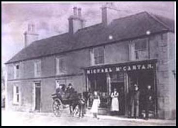
Garvaghy | . | a village & residence & farm of Monsignor McCartan in 1890s; Catholic chapel & school here; see under Ballooly | MOF p5; PNNI V6 p193; DDPP p55,61 |
| Ballemacathan | Comber | . | alternate name for Ballymagaughey townland in 1615 | O'L B p327 |
| Ballemackley | Newtownards | . | or Tulleymuckley; Ancient townland in 17th century in East Down;grant by King Charles 1st to Hugh, Viscount Montgomerie; possibly Crossnamuckley | V17 p123 OSM |
| Ballemagarth |
Kilkeel
|
. | alternate spelling for Ballymagart townland in rent roll of 1688 | PNNI V3 p 25 |
| Ballemagough |
Kilkeel
|
. | alternate spelling for Ballymageogh townland in rent roll of 1688 | PNNI V3 p 25 |
| Ballemincock |
Greyabbey.
|
. | alternate name for Ballymurphy townland in 1623 | V17 p122 OSM; PNNI V2 p 204 |
| Balle Moenestraghe | Kilmood | . | alternate spelling for Ballyministragh townland | V7 p68 OSM |
| Ballemonestraduffe | Ballyhalbert | . | alternate name for Black Abbey in 1623 | PNNI V2 p 99 |
| Ballemullen | Bangor | . | alternate spelling for Ballymullan townland in 1659 census | PNNI V2 p 159 |
| Ballemurcock | Greyabbey | . | alternate name for Ballymurphy townland in 1636 | V7 p68 OSM; PNNI V2 p 204 |
| Ballenagallbec | Ardglass | . | alternate name for Ballykilbeg townland c. 1520 | O'L B p 283, 284 |
| Ballenaboyle, the Cardie |
Grey Abbey |
21: 58/70
|
Ancient townland in 17th century in East Down;grant by King Charles 1st to Hugh, Viscount Montgomerie; possibly called Cardy today | V7 p68 OSM |
| Ballenahatten | Kilkeel | . | alternate spelling for Ballynahatten tonwland in 1774 | PNNI V3 p 27 |
| Balleneddan | Kilbroney | . | alternate spelling for Ballyneddan townland on Rent Roll of 1688 | PNNI V1 p 142 |
| Ballenellan | Grey Abbey | . | or Balleranellan; ancient townland in 17th century in East Down;grant by King Charles 1st to Hugh, Viscount Montgomerie ;possibly Ballyurnanellan | V17 p122 OSM |
| Ballencorry | Kilbroney | . | alternate speling for Ballincurry townland in Rent Roll of 1731 | PNNI V1 p 135 |
| Ballenescore | . | . | ancient townland in 17th century in East Down;grant by King Charles 1st to Hugh, Viscount Montgomerie ' could be Ballyspurge | V7 p68 OSM |
| Ballenestroth | Aghaderg | . | alternate name of Ballynakseag townland in 1615 | O'L B p 326 |
| Ballengrevagoin | Ballyphillip | . | or Ballagin; Ancient townland in 17th century in East Down;grant by King Charles 1st to Hugh, Viscount Montgomerie ;could possibly be Ballygarvigan | V17 p123 OSM |
| Balleno | Donaghadee | . | alternate spelling for Ballynoe townland in 1659 census | PNNI V2 p 185 |
| Ballenocross | Donaghadee | . | alternate spelling for Ballycross townland in 1659 census | PNNI V2 p 182 |
| Balleny | Dromore | 20: 19/51 | 2km SW of Dromore;817 acres; click here to see its location on a townland map; school here in 1836; means ' Heaney's townland'; church lands until 1868; residence of William Harrison, owner of Dromore Castle in 1888; Arian/Non- Subscribing Presbyterian church built here 1724 | V12 p73 OSM; MSWAG p25; V 19 MIs;GIC; PNNI V6 p 110 |
| Balleoran | Inch | . | tithes paid to Catholic church in 1615; land & tithes granted to Lord Clandeboy in 1629 | V17 p133 OSM; O'L B p 326 |
| Balleran | Kilbroney & Kilkeel |
. | alternate spelling for Ballinran townland on Rent Roll of 1688 | PNNI V1 p 138 & V3 p 22 |
| Balleranellan | Grey Abbey | . | alternate spelling for Ballyurnanellan townland | V17 p122 OSM |
| Ballerea |
Newtownards
|
. | alternate spelling for Ballyreagh townland in 1659 census | PNNI V2 p 223 |
| Ballerie |
Bangor
|
. | alternate spelling for Ballyree townland in 1661 | PNNI V2 p 159 |
| Ballerogan |
Kilkeel
|
. | alternate spelling for Ballyrogan townland in rent roll of 1688 | PNNI V3 p 27 |
| Ballethoniam |
Bright
|
. | alternate spelling for Coniamstown townland in 1615 | O'L B p 322 |
| Balletullegrange |
Inishargy
|
. | alternate name for Gransha townland c. 1615 | V17 p123 OSM; PNNI V2 p 90 |
| Balleurgegan | Inishargy | . | land & tithes granted to Lord Clandeboy in 1629; possibly Ballyobegan | V17 p133 OSM |
| Balleveregan | Rathmullan | . | alternate name for Ballyorgan townland in 1615 | O'L B p 322 |
| Ballevranellan | Greyabbey | . | alternate spelling for Ballyurnanellan in 1636 | V7 p68 OSM' PNNI V2 p 205 |
| Ballevy Balleevy Ballievey |
Seapatrick | 20: 15/45 | 3km SE of Banbridge;476 acres; click here to see its location on a townland map; means 'approach to a pleasant ford'; owned by Edward Trevor in 1618; the prorietor in 1795 was George Crawford; tenants were Thomas & George Crawford & H. McMurdock in 1836; Ballevy House here, estate of N.C. Whyte Esq.in 1836; mills of Lord Dungannon here; suspension bridge built here over River Bann | V12 p123,126, 133 OSM; UJA;old b/w map G7; PNNI V6 p 304; OB p41 |
| Ballevy House |
Seapatrick | . | the prorietor in 1795 was Walter Crawford; residence of Walter Crawford in 1824 & George Crawford in 1910 | UJA;POD |
| Ballewatecock | Newtownards | . | alternate spelling for Ballywatticock townland in 1659 census | V17 p123 OSM; PNNI V2 p 225 |
| Ballievey | Seapatrick | . | alternate spelling for Ballevy townland | . |
|
Balliggan |
Inishargy | 21; 62/65 | 4km SW of Ballywalter; 303 acres;means ' O'Higgins townland' ; granted by King Charles 1st to Hugh, Viscount Montgomerie c. 1623; in 1659 there were 7 English/Scots & 3 Catholic families here; Inishargy parish church is in this townland; a wind driven flax mill in 1836 | V7 p5, 85 & V17 p123, 125 OSM;SP; PNNI V2 p 86 |
| Ballillymore | Garvaghy | . | see Balloolymore | V12 p81 OSM |
| Ballilurgan | Kilclief | . | name of an ancient chapel & rectory in 1661; in Ballywoodan townland | O'L V1 p 203 |
| Ballimahattin | Kilkeel | . | alternate spelling for Ballynahatten townland in 1804 | PNNI V3 p 27 |
| Ballinabragget | Donaghcloney | . | alternate spelling for Ballynabragget townland | V12 p60 OSM |
| Ballinafern | Annaclone | 29: 17/39 | or Ballynafern;3km SW of Annaclone village; large hill 537 ft; school here in 1836; 778 acres; proprietor Charles Douglass Esq. in 1836 | V12 p13, 15, 16, 19 OSM |
| Ballinafoy | Annaclone | 20: 15/40 | or Ballynafoy;3km W of Annaclone village; 901 acres; click here to see its location on a townland map; means ' townland of the green'; large hill 612 ft ;an ancient clan meeting spot & Mass Rock ; Cave Hill here ; proprietor William S Crawford Esq. In 1836 | V12 p13141516 OSM; PNNI V6 p 66 ; DDPP p133 |
| Ballinagoppoge | Clonduff | . | alternate spelling for Ballynagoppoge townland | V3 p4 OSM |
| Ballinagross | Ballee | . | alternate spelling for Ballynagross townland | V17 p20 OSM |
| Ballinahatten | Kilkeel | . | alternate spelling for Ballynahatten townland | TU p121 |
| Ballinahatty | Drumbo | . | alternate spelling for Ballynahatty townland | . |
| Ballinamorna | Kilkeel | 29: 26/19 | on the slopes of The Mournes, 5km NNW of Kilkeel |
PNNI V3 p 56
|
| Ballinany | Annaclone | . | spelling for Ballynanny townland c. 1824 |
PNNI V6 p 67
|
| Ballinapistragh | Grey Abbey | . | alternate name for Ballyblack townland in 1627 |
V7 p68 OSM
|
| Ballinarry | Saul- a detached townland | 21: 57/45 | 5km S of Strangford town; 366 acres; means ' townland of the meeting place' ; click here to see its location on a townland map; Brannigan family in 1880s; also spelt Ballynarry |
Inv 2013 p4
|
| Ballinatagart | Aghaderg | 29: 11/40 | also spelt Ballintaggart; 3km S of Loughbrickland; 503 acres; means 'priest's townland'; click here to see its location on a townland map | V12 p1 OSM |
| Ballinaulta |
Newtownards
|
. | alternate name for Ballyhaft townland in 1623 | V17 p123 OSM; PNNI V2 p 220 |
| Ballinavalley |
Drumbo
|
. | see Ballynavally | . |
| Ballinchole | . | . | ancient townland in 17th century in East Down;granted by King Charles 1st to Hugh, Viscount Montgomerie c. 1623 | V17 p123 OSM |
| Ballincleave Ballinclave |
Ballyculter | . | alternate spelling for Ballintlieve townland | . |
| Ballincrag | Newry | . | alternate spelling for Ballynacraig townland | PNNI V1 p 9 |
|
Ballincurry Ballincurry Upper |
Kilbroney | . | 260 acres & 52 acres;on the shore, 5km SE of Rostrevor; click here to see its location on a townland map; means ' townland of the bog'; ancient Mass stone here; originally belonged to Donald & James McYawne then Nicholas Bagnall in 1568 & owned by Lord Nicholas Bagenal in 1690s ; the proprietor was Mr Buston in 1836 | V3 p31 OSM;DDPP p120; PNNI V1 p 135; MO 5/8/2009 p6 |
| Ballincurry River | Kilbroney | 29: 21/16 | rises on Slievefadda and flows SE into Carlingford Lough near Seafield | . |
| Ballinderry Lower | Blaris | . | In 1836 applotter was John Gawley & appraiser was James Johnston; Thomas B Reford & John Turtle were to repair and widen Magee's town Lane in Tannyballydonnell & levied off Lower Ballinderry tithes; weavers meeting 15 Oct 1842 near Moira | V12 p404, 142 OSM : DR |
| Ballinderry Upper | Blaris | . | In 1836 applotter was Howe Higginson & appraiser was Turtle Bunton;letter to Henry Peel & George Higginson to repair that part of the Old Templecormack Road between the burying place and William Maxwell's gate & to be levied off Upper Ballinderry's tithes | V12 p404, 142 OSM |
| Ballindoalty | Kilbroney | . | on the shore of Carlingford Lough; 212 acres; click here to see its location on a map; means ' An Dubhaltach's townland'; originally owned by Donald & James McYawne then Nicholas Bagnall in 1568; owned by Lord Nicholas Bagenal in 1690s ; proprietor Mr R. & Mr J Small & J. Dickey in 1836 | V3 p283, 132 OSM; PNNI V1 p 136 ; MO 5/8/2009 p6 |
| Ballindoalty Upper |
Kilbroney
|
. | 6km SE of Rostrevor; 78 acres; click here to see its location on a townland map | . |
| Ballineboyle the Cardie |
Grey Abbey
|
21: 58/70
|
ancient townland in 17th century in East Down;grant by King Charles 1st to Hugh, Viscount Montgomerie ; possibly called Cardy today | V17 p122 & V7 p 68 OSM |
| Ballinegapke | Clonduff | . | alternate name foe Ballynagappoge townland in 1659 census | PNNI V3 p 80 |
|
Ballinegrange |
Grey Abbey | . | ancient townland in 17th century in East Down; grant by King Charles 1st to Hugh, Viscount Montgomerie ;also called Killenanaghe & Tullymuckly;could possibly be Ballygrangee | V17 p123 & V7 p68 OSM |
| Ballinekenidd | Kilcoo | . | an alternate name for Ballymoney townland c. 1610 | PNNI V3 p 71 |
| Ballinepistragh | Grey Abbey | . | or Balleblake; ancient townland in 17th century in East Down;grant by King Charles 1st to Hugh, Viscount Montgomerie ;most possibly called Ballyblack now | V17 p123 OSM |
| Ballineskeagh | Aghaderg | . | Bishops land £2 in 1744; see Ballynaskeagh | V17 p118 OSM |
| Ballingossop | Clonduff | . | see Ballynagoppoge | V3 p4 OSM |
| Ballingowen | Aghaderg | . |
see Ballygowan
|
. |
| Ballinlare | Newry | . |
a townland just SW of Newry town; 265 acres; in Co Armagh
; click here
to see its location on a townland map;
means 'townland of the gap';
|
PNNI V1 p 7 |
| Ballinlogh | Donaghcloney | . | spelling for Ballynabragget townland in s deed of 1719 |
PNNI V6 p 87
|
| Ballinmacoraham | Moira | . | alternate name fo Ballymagaraghan townland on Rent Roll of 1692 |
PNNI V6 p 283
|
| Ballinran | Kilbroney | . | a townland on the shore 3km SE of Rostrevor ; click here to see its location on a townland map; means 'townland of the point'; originally owned by Donald & James McYane then Nicholas Bangall in 1568 & owned by Lord Nicholas Bagenal in 1690s ; coastguard watch & boat house here in 1863 |
PNNI V1 p 137 ; MO 5/8/2009 p6;GV
|
| Ballinran Upper |
Kilbroney |
29:29/21
|
a townland 3km SE of Rostrevor; 80 acres; click here to see its location on a townland map | . |
| Ballinran |
Kilkeel |
29:30/19
|
townland of 195 acres; 4km N of Kilkeel; 890 acres; click here to see its location on a map ; means ' townland of the ferns' ; part of the Bangenal Estate in 1552; stone here where Priest Magrorey was stabbed to death trying to seetle a dispute in a football match 1670; proprietor D. Ross Esq. Lodge in 1836; | V3 p31 OSM: CM; O'L V1 p 18;PNNI V3 p 21 |
| Ballinran Upper | Kilkeel-part | . | a townland on the slopes of The Mournes, 8km W of Annalong; 550 acres; click here to see its location on a map | . |
| Ballinree Burn | Killinchy | 21: 48/60 | runs through Killinchy & into Strangford Lough | . |
| Ballinseagh | Newtownards | . | ancient townland in 17th century in East Down; grant by King Charles 1st to Hugh, Viscount Montgomerie ;see Movilla | V17 p123 OSM |
| Ballintaggart Ballinatagart |
Aghaderg | 29: 11/40 | a townland of 503 acres; 3km S of Loughbrickland ; click here to see its location on a townland map; means ' townland of the priest'; owned by the Bishop of Dromore, held by Shane McBrin in 1611 | V12 p 81 OSM; PNNI V6 p 23, 24 |
| Ballintanpany Ballintimpany |
Magheradrool | . | ancient names for Magheratimpany townland |
DR* 9/10/1970
|
| Ballintemple | Newry | . | rrsidence of Rev. Henry Boyd, rector of Rathfriland in 1821 |
CSO
|
| Ballintine | Blaris | 20: 26/63 | a townland 1km SW of Lisburn; 190 acres; click here to see its location on a townland map | . |
| Ballintleyne | Ardquin | . | alternate name for Thomastown tonwland in 1661 | PNNI V2 p 36 |
| Ballintlieve Ballinclave |
Ballyculter | . | a townland 2km W of Strangford; click here to see its location on a townland map; owned by the Southwell Estate in 1752; owned by heirs of Lord De Clifford & Lord Bangor in 1836; high rocky soil partly uncultivated; residence of the Rogan, McGreevy, Cooper, Hynds, Wright families late 1800s | LM 1881 p26; V17 p30 OSM; Inv 1997 p 3; Inv 2010 p3 (OS map 1830s) |
| Ballintober Ballintubber |
Bright | . | 4km NW of Killough; means ' town of the well'; Catholic church here | old b/w map N15; O'L V1 p 148 |
| Ballintogher Ballintougher |
Saul | 21: 51/48 | a townland 4km NE of Downpatrick on the Strangford road; click here to see its location on a townland map; means ' town of the causeway'; site of an ancient church called Ballybrene;where St Patrick landed c. 432; owned by Nuns of Down in 1615; owned by the Southwell Estate in 1752 & leased to Cromwell Price Esq.; corn mill & school here in 1836; owned by heirs of Lord De Clifford & Francis Savage Esq. in 1836 | V17 p111, 114, 115 OSM;LM 1991 p25; O'L V1 p 224 & B p 284, 322; Inv 2003 p41 |
| Ballintur | Kilbroney | 29: 22/15 | a townland on the shores of Carlingford Lough, 5km SE of Rostrevor;226 acres; click here to see its location on a townland map; means ' townland of the bush'; ancient Mass stone here in Fitzsimmons' Braes; owned by Lord Nicholas Bagenal in 1690s ; proprietor Lord Kilmorey in 1836 | V3 p32 OSM; DDPP p120; CM; MO 5/8/2009 p6; PNNI V1 p 138 |
| Ballintur Upper |
Kilbroney
|
. | a townland 6km SE of Rostrevor; 140 acres; click here to see its location on a townland map | . |
| Balliruggan |
Kilkeel
|
. | alternate spelling for Ballyrogan townland in 1663 Subsidy Roll | PNNI V3 p 27 |
| Ballisciagh |
Aghaderg
|
spelling for Ballynaskeagh townland in 1659 Census | PNNI V6 p 25 | |
| Ballnamgrange |
Donaghadee
|
. | alternate name for Grangee townland in 1623 | V17 p123 OSM; PNNI V2 p 191 |
| Balloo Ballow |
Bangor |
15:52/79
|
a townland of 533 acres: click here to see its location on a townland map; means ' Hugh's townland'; in 1659 there were 6 English/Scots & 4 Catholic families here; 12 acres of uncultivated land in 1836;railway line here in 1863 | V17 p123, 124 & V7 p19 OSM;SP; BM; PNNI V2 p 150;GV |
| Balloo House Ballow House |
Bangor | . | house & farm of 108 acres; 3km S of Bangor town; in possession of Nicholson family since 1641; main house of 18th -early 19th century date; residence of Miss Susanna Nicholson in 1729; the [roprietor in 1795 was W. S. Nicholson; held in fee by Robert S. Nicholson in 1863; residence of Mrs Nicholson in 1901; burnt by vandals & pulled down c. 1970; Mausoleum gravestones UHF Vol 17 | UJA;V7 p23 OSM; old b/w map W7; Burke's Landed Gentry Vol2 p934 (1847); GV;POD; MIs |
| Balloo Lower | Bangor |
15:55/83
|
1km SE of Groomsport; click here to see its location on a townland map | PNNI V2 p 150 |
| Balloo | Killinchy | . | a townland of 474 acres; click here to see its location on a townland map ;means 'Hugh's townland' ;had a gravel pit near the mill consisting of slate, greywacke & quartz ;Presbyterian meeting house here ;infanticide 17 Mar 1877 | V7 p86, 88, 91 OSM: DR; GIC |
| Balloo Cross Roads | Killinchy | 21: 49/61 | in Killinchy town | . |
| Balloo House | Killinchy | . | a 2 storey Georgian house, which stands at the corner where the road from Ardmillan joins the road to Comber in the townland of Balloo; keystone above the front door reads 'built by David Lowry 1809 AD'; photos & more information available | LM 1991 p26-31 |
| Ballooly Ballully Ballella |
Garvaghy | . | a townland of 428 acres; click here to see its location on a townland map; means ' stony place'; church lands, ;school in ploughmans cottage established 1834; Catholic chapel here; woods; resident proprietor Roger Maginnis Esq. in 1836; rents at 42 shillings an acre;2 mills, one for shelling corn in 1836; also spelt Ballela & Ballyilly | V12 p80, 82,83,113 & 3 p 111 OSM; V5 MIs; GIC; PNNI V6 p 191, 192; DDPP p55 |
| Ballooly House | Garvaghy | 20: 19/48 | farm estate ; 2km SW of Garvaghy village;residence of Roger Maginnis Esq. in 1822 & 1836 |
DDPP p53; V12 p80 OSM
|
| Balloolymore Ballyillymore |
Garvaghy | 20: 19/43 | a townland 8km E of Banbridge; 916 acres:click here to see its location on a townland map; means ' large townland of stony place'; corn & flax mill here in 1836; standing stones;Tenant Rights agitation 29 Mar 1851 | V12 p80, 81 OSM; PNNI V6 p 193 |
| Balloonigan | Moira | . | a townland 1km E of Moira town; 154 acres; click here to see its location on a townland map; means ' O'Donegan's townland; lowest part of the parish; proprietor Sir. R Bateson in 1836 | V12 p109, 120 OSM; PNNI V6 p 279 |
| Ballotheneirry | Kilkeel | . | alternate name for Ballaghanery townland in 1615 | O'L B p 323 |
|
Ballow |
Bangor | . | see Balloo | . |
| Ballow Lower | Bangor | . | a townland of 383 acres; 3km E of Bangor |
BM
|
| Ballow | Killinchy | . | see Balloo | . |
| Balluley | Garvaghy | . | alternate spelling for Ballooly townland | PNNI V6 p 193 |
| Ballvree | Bangor | . | farm; 2km SE of Bangor | BM |
| Bally....... | . | . | click here for Ballya....- Ballyl.... & click here for Ballym....- Ballyw.... | . |
| Balumigan | Moira | . | alternate spelling for Balloonigan townland in 1659 census | PNNI V6 p279 |
Last updated November 2022
by Ros Davies