 |
Ros
Davies'
Co. Down, Northern Ireland Family History Research Site © Rosalind Davies 2001 Permission granted to reprint research for non-profit use only |
 |
Place Names of Co. Down: N....
| Na - Ne | Ni.......Nz |
| Place Names | Parish | Information | Reference | |
| Loughinisland | . | 336 acres; Clough area; click here to see its location on a map; means the little ford;in 1659 there were 15 English/Scots & 6 Catholic families here; Seceders church on site of ancient Catholic chapel; the population in 1841 was 96 & in 1851 60 & in 1861 16 people | V17 p 96 OSM;HCDTD p38,40 ; LCB p 17, 81 | |
| Nachestowne | Ardquin | . | alternate name for Ballyminnish townland in 1620 | PNNI V2 p 31 |
| Nacoma | Holywood | . | a house in Cultra; home of the Irish spiritual medium Kathleen Golighy (b.1898- d. 1972) & Col. H.R. Charley in 1950s | PE |
| Nahor's Quay | Moira | . | the proprietor in 1795 was Mr. Frazer |
UJA
|
| Nailer's Brae | Saintfield | . | a steep hill here | SHM '86 p 9 |
| Nannie's Sound | Bright | . | a large basin of water on the coast which was blocked off in 1820 | KCL p 74 |
| Narrow Water | Warrenpoint | 29: 12/20 | townland; 2km NW of Warrenpoint; formerly in Clonallan parish until 1825; click here to see its location on a townland map; this area was originally owned by Sir Hugh Mahennis c. 1580; corn mill here in 1836 ; proprietor Roger Hall Esq.in 1836; flax mill here ;school established 1829: Farming Society 3 Mar 1838; harvest home 26 Oct 1867; Cottage Gardening Society 14 Aug 1880; Seceding Presbyterian church here | WDG p51; V3 p 115, 116, 122 OSM:MS WAG p 48; DR: HMNI p106; GIC; PNNI V1 p 163; IPP p 112 |
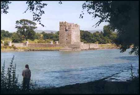
| Narrow Water Castle | Warrenpoint | . | ancient castle & 353 acres ,owned by Roger Hall in 1863 ; click here for a photo |
GV
|
| Narrow Water Forest | Warrenpoint | 29: 11/20 | large wood on Newry River, 3km NW of Warrenpoint | . |
| Natal Terrace | Holywood | . | row of 4 houses in Palmerston Rd, Strandtown |
POD
|
| Needoo | Ardkeen | 21: 57/59 | in Strangford Lough, 3km W of Cookstown; means 'the black nest' |
PNNI V2 p 22
|
| Negoward | Clonduff | . | alternate name for Goward in 1612 |
PNNI V3 p 87
|
| Neills Bridge | Loughinisland | . | 3km W of Downpatrick |
old b/w M 12
|
| Neills Cottage | Kilcoo | . | in Bryansford Rd, Newcastle;residence of Mrs Morrison in 1910 |
POD
|
| Neills Hill | Ballymacarret | . | site of a railway station in 1890 ; Belfast to Comber |
NWAG p 37 map; TMUOP p126
|
| Nendrum | Tullynakill | 21; 52/64 | on Mahee Island in Strangford lough, click here for a photo of the ancient monastic site and castle |
.
|
| Nest (The) | Kilcoo | . | house & 2 acres in Bryansford villages ; held in fee by Earl of Roden in 1863; residence of Rev. Arthur Langtry & Ross Langtry in 1910 | GV; POD |
| Nestleton | Knockbreda | . | 2 attached houses in Kings Rd, Belfast near Knock Road in 1902 |
POD
|
| Net Hole | Dunsford | . | popular fishing spot near Guns Island |
Inv 2000 p 6
|
| Netherleigh | Holywood | . | in Strandtown; residence of William Robertson in 1886 | POD; P7/19 CBSA |
| Netherwood | Knockbreda | . | in Knock Rd, Belfast near Kensington Road; residence of Donald G. Caldwell in 1902 |
POD
|
| Nettlefield House | Knockbreda | . | house & large garden in off Cherryville St, near Woodstock Rd Ballymacarrett; residence of Frederick Lewis in 1852; owned by Mrs. Lewis in 1876 with 11 acres; house still there in 1902 |
POD; OS map 1902 4.11; LOI
|
| New Bridge | Clonduff | 29: 23/29 | over river Bann ;3km E of Hilltown on Spelga Pass road | . |
| Newcastle | Slanes | 21: 63/53 | a townland of 226 acres; 4km NE of Portaferry; click here to see its location on a townland map; means ' the new castle', which was a ruin by 1617; the village was described in 1836 as small with having houses of one storey with much poverty; there was a light-house on the shore in 1837; proprietor Rev. Mr. Blacker of Markethill in 1836;death of "Rose-Curer" Francis Smith 18 Apr 1874 | V17 p 125, 127 & V121 OSM;DR; PNNI V2 p 117 |
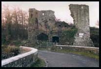
| Newcastle | Kilcoo | 29: 37/31 | a town on the coast, 4km SE of Castlewellan; click here for a photo and more information | . |
| New Comber House | Comber | . | house & farm of 17 acres in Cattogs townland; 2km SE of Comber town; near Strangford Lough ; leased by John Smith in 1863 from Marquis of Londonderry; residence of James Smyth c. 1860 & Henry D. Ritchie in 1870 & Hamilton Coulter in 1899 & 1912 |
old b/w map R8;GV; POD ; ACOC p25
|
| New-Culter | Ballyphilip | . | proprietor in 1836 was Rev. Mr. Blacker; |
V7 p 8 OSM
|
| Newells Cross | Kilkeel | 29: 24/15 | crossroads ; Kilkeel to Rostrevor road & Greencastle road |
PNNI V3 p 63
|
| Newerk | Ardglass | . | 'the new works of Ardglass', held by Sir Jancio D'Artois in 1427 |
O'L V1 p 168
|
| Newfield | Bangor | 15:55/78 | farm; near Cotton townland; 5km SE of Bangor town | . |
| New Forge | Hillsborough | . | near Hillsborough; residence of John McClughan & Charles F. Nash & John Russell in 1852; Old Forge is in Drumbeg parish |
MIs; POD
|
| New Forge House | Magheralin | . | farm; just S of Magheralin village in Drumcro townland; now called Drumcro House; residence of James Pickering 1840s-1850s & Henry Frederick Hole Esq. in 1858 |
old b/w map J 3; PNNI V6 p 237; PR; MIs
|
| Newforte | Newtownards | 21: 45/73 | farm; 4km SW of Newtownards | . |
| Newfoundland | Dromara | . | a farm in Drin townland, leased by Daniel Davey in 1821 |
TEP: PRONI D/788/324
|
| Newgrove | Blaris | . | near Lisburn; 233 acres owned by Crommelin Irwin in 1876 |
LOI
|
| New Grove | Drumbo | . | residence of John Younghusband in 1793 & Councillor Thomas Hutchenson in 1833 & Robert Anderson c. 1870; described as a small but desirable residence |
V7 p 56 OSM ; MIs
|
| Newgrove | Kilmore | 21: 43/55 | farm, in Clontinaghnaglar townland | . |
| Newgrove | Magherahamlet | . | farm; 2km S of Spa |
old b/w map L10
|
| New Lagan Bridge | Knockbreda | . | over the Lagan River just S of Ballymacarret town |
V7 p 98 OSM
|
| Newmarket Lodge | Knockbreda | . | in Knock Rd, Belfast near Cherryvalr Road; residence of Robert H. Clegg in 1902 |
POD
|
| Newmill Bridge | Moira | 20: 16/60 | over river Lagan ;2km SE of Moira; southern border of Aughnadrumman townland |
PNNI V6 p 278
|
| Newmills | Tullylish | 20: 6/52 | in Ballynagarrick townland; mill here in 1739 & 1834; Presbyterian church burnt down in 1797 but rebuilt ; the proprietor in 1795 was John McMurrin; John McMurrin, linen manufacturer here in 1824 |
GIPR; PNNI V6 p 352; UJA; POD
|
| New Quay | Ballyculter | . | near Strangford |
Inv 2014 p7 (map),8
|
| New Orchard | Moira | . | a farm ; residence of James Swain in 1910 |
POD
|
| Newport | Blaris | . | a townland 3km N of Hillsborough town; in Maze townland; the proprietor in 1795 was Jeremiah Harvey; school built 1818; Sunday school here;one of the quays on the Lagan Navigational Canal; reisdence of Jane Prenter in 1808 & 1836 | UJA; V12 p35,38,101 OSM; old b/w map M4; ODHD p39 RD |
| Newry | Newry | 29: 8/27 | a parish & a large town on the border with Co Louth, Co Armagh & Co Down; click here for a photo and more information ; means' yew tree' | HCPCI p289 |
| Newry Arms | Newry | . | an inn in Hill St, Newry ; the proprietor in 1846 was Adam Black |
POD
|
| Newry Hotel | Newry | . | an inn in Corry Square, Newry ; the proprietor in 1910 was Mrs Heaney |
POD
|
| Newry Hotel | Warrenpoint | . | an inn in Warrenpoint; the proprietor in 1846 was James White |
POD
|
| Newry Quay | Ballyculter | . | in Strangford; site of Newry Timber & Slate Company depot in 19th century for storing timber |
Inv 2006 p40
|
| Newry River | Newry | 29: 8/31 | runs S into Newry Canal | . |
| Newton Rock | Inishargy | 21: 56/63 | in Strangford Lough, 4km W of Kircubbin | . |
| Newtown | Ardglass/ Dunsford | . | Villa Nova, on a list of Bishop's lands in 1210 returns | O'L V1 p 179; Inv 2002 p 55; LM 1999 p90 |
| Newtown or Newton |
Kilbroney | . | a townland of 432 acres: click here to see its location on a townland map; bog here; proprietor David Ross Esq. in 1836; Quaker meeting house here; a betling mill here in 1886 | V3 p 26, 32 OSM; GIC; PNNI V1 p 151; POD |
| Newtown Upper | Kilbroney | . | a townland of 213 acres; click here to see its location on a townland map; cleared by Catholic steelers from Co. Armagh c. 1780 |
PNNI v1 p 151
|
| Newtown | Seapatrick. | . | village in Kilpike townland; 2km NNW of Banbridge | old b/w map G5;GV |
| Newtown Newtownards |
Newtownards | 21: 49/74 | large town and a parish; 8km SE of Belfast on the Donaghadee road; click here for a photo of the old town square, more information & newspaper indexes ; click here for a map of the townlands | . |
| Newtownbreda | Knockbreda | 20: 36/70 | a village ;on the Belfast to Downpatrick road; in 1832 the 62 houses very kept in good order; 10 two-storey & 25 one-storey houses were thatched; it had one hotel & one street with houses only on one side with the other being Belvoir Park demesne, home of Sir Robert Bateson Esq. M.P.;there were many gentlemen's seats with woodland surrounding them: the Church of Ireland, Presbyterian & Methodist meeting houses here ;there were 2 carpenters, 1 dish turner, 1 blacksmith, 5 nailors, 3 tailors, 1 saddler, 4 shoemakers, 3 small grocers, a benevolent society and a dispensary; 4 schools here ; incendiary fires 3 Feb 1849; elevation of Sir Thomas Bateson to peerage, Lord & Lady Deramore 5th Dec 1885 (DR); mystery 4 Jul 1891 (NC) | V7 p 101,102 OSM: DR ; GIPR; NC |
| Newtown Bridge | Kilbroney | . | 1km NE of Rostrevor |
old b/w map A13
|
| Newtown Hayes | Seapatrick | . | residence of John Wetherhead, thread merchant in 1846 |
POD
|
| Nicholsons Cross Roads | Dromara | 20: 26/52 | between Drumadoney & Lappage townlands | . |
| Nicholsons Point | Kilkeel | 29: 29/12 | juts out into the Irish Sea, 2km SW of Kilkeel |
PNNI V3 p 63.
|
| Nicholstown | Ballytrustan | . | alternate name for Ballynichol townland in 1333 |
PNNI V2 p 59
|
| Nickeys Point | Killyleagh | 21: 52/51 | in Strangford Lough, 2km S of Killyleagh | . |
| Norelands | Down | . | sudden death of Clayton Savage Esq. of Norelands, Hollymount estate 12 Jun 1858 | DR |
| Normanville | Bangor | . | 3 attached houses in Hamilton Rd, Bangor in 1902 |
POD
|
| North Boretree Rock | Grey Abbey | 21: 54/69 | rock in Strangford Lough, 2km W of Pattersons Hill | . |
| Northcote Villa | Knockbreda | . | now 95 King's Rd, Knock village ; built c. 1890; photo available | ACC p38 |
| North Down House | Comber | . | a pub near McDonald's Corner, Comber ; owned by Mr Todd c. 1900 then became Railway Tavern c. 1925 then back to original name; won award in 1967 | TOOC p96 |
| Northfield | Donaghadee | . | villa in Killaughey Rd, Donaghdee; residence of W.F. Walker in 1910 | POD |
| North Lodge | Newry | . | residence of James Law McCance R.M. in 1864 & Allan MacDonnell in 1886 | CR; POD |
| North Quay | Ballyculter | . | near Strangford | Inv 2014 p7 (photo) |
|
North Rock |
Slanes | . | in Cloghy Bay ; many wrecks; in 1683, 18 sailors were drowned & buried in Slanes churchyard; site of a lighthouse; barquentine Titania wrecked 2 Feb 1879; barque Amanda wrecked 26 Jun 1881; steamer Craigrownie wrecked 13 Dec 1881; wreck of emigrant vessel Wild Deer 20 Jan 1883 | V7 p 1 OSM:DR; BoTWR/MB; PNNI V2 p 118,119; JUAHS 2011 p20 (map) |
| North Rock | Comber | 21: 52/69 | in Strangford Lough, half was between Comber & Grey Abbey; shipwreck of schooner 'Titani' 8 Feb 1879 |
DR
|
| North Tor | Kilkeel | . | a peak near Dunnywater in Mourne Mountains; photo available |
CP 31/7/2013
|
| Norwoodstown | Hillsborough | . | farm estate; 3km E of Hillsborough town |
old b/w map M6
|
| Norwood Tower | Holywood | . | house & farm of 15 acres in Ballymisert townland ,Circular Rd, Strandtown; leased by James A. Henderon in 1863 from David S. Ker; death of James Alex Henderson Esq. J.P. son of the proprietor of Newry Telegraph newspaper 14 Apr 1883 ; residence of Charles W. & H. Trevor Henderson in 1902 |
GV; DR; POD ; ACS p10,11
|
| Nugent Arms | Ballyphilip | . | a hotel in Portaferry; licence transfered from Mrs. McMullan to Messrs. William P. McCall, Edward McCall & Thomas McCall of Newtownards 4 Feb 1911; re change of ownership & sale of contents of building 14 Oct 1912 |
JUAHS 2011 p35 & 2012 p39
|
| Nuns Bridge | Slanes | 21: 62/55 | over Ballyfinragh river; 5km N of Portaferry ; Nunsbridge House near here c. 1870 in Ballygalget |
O'L V1 p 416; PNNI V2 p 137
|
| Nun's Gate | Down | . | at the corner of Bridge & Church Street, Downpatrick on 1729 map; near the Nunnery of the Blessed Mary (Cistercians) | O'L V1 p 259; LR 2012 p62 |
| Nunsquarter | Inishargy | 21: 59/64 | a townland 4km S of Grey Abbey; 178 acres; click here to see its location on a townland map; means 'quarter of the Nuns'; Catholic church here | V17 p125 OSM; GIC; O'L V1 p 428; PNNI V2 p 93;GV |
| Nunsquarter House | Inishargy | . | house & farm of 123 acres; the proprietor in 1795 was James Allen; held in fee by James Allen in 1863 ; residence of William Allen in 1910; click here for a photo |
UJA; GV; old b/w map V14; POD
|
| Nunstown | Bright | . | alternate name for Ballynagallagh townland because of several stone lined graves | O'L V1 p 151, 259 |
| Nun's Walk | Magheralin | . | in Ballymakeonan townland near old churchyard | PNI V6 p 226 |
| Nursery Villa | Comber | . | residence of John Simonton in 1870 | POD |
| Nurseryville | Comber | . | house & farm estate of 49 acres in Ballyloughan; 2km NNW of Comber town; a prioprietor in 1795 was John Harvey; residence of John Harvey in 1824 & leased by William Campbell in 1863 from Marquis of Londonderry & William Berkeley in 1899 | old b/w map R7; UJA; GV; POD |
| Nut Grove | Kilbroney | . | in Rostrevor; residence of Robert Martin Esq. in 1846 | POD |
| Nutgrove | Loughinisland | 21: 42/44 | farm, 2km SE of Loughinisland village; mill here ; mansion, demesne & flour mill to let in 1836; residence of James Wardlow in 1794 & Mrs. Catherine Keys in 1846 & Andrew McCammon c. 1863 & D.G. McCammon in 1895 | LCB p 16, 32; PRONI name search; PR; LM 1995 p75; LR 2018 p42, 44 |
| Nut Hill | Moira | 20: 19/59 | in Ballyknock townland ;E of Moira |
PNNI V6 p 283
|
| Nuthill Bridge | Moira | 20: 19/60 | over old canal in Ballyknock townland | . |
| Nutt Lough | Kilmore | . | very small lake in Drumnaconnor townland | BN 15/6/1764 |
By Ros Davies