 |
Ros
Davies'
Co. Down, Northern Ireland Family History Research Site © Rosalind Davies 2001 Permission granted to reprint research for non-profit use only |
 |
Place Names of Co. Down: A......
| Ab- Ai | Al - An | Ar- As | At- Au |
| Place Names | Parish | Map Ref | Information | Reference |
|
Abbacie |
Ardquin | 21: 58/55 | house; 3km NNW of Portaferry; former residence of Bishop Echlin c. 1630s; destroyed by Cromwells's troops; Church of Ireland here | V17 p126 OSM; old b/w mpa T15; PNNI V2 p 36 |
| Abbey (The) | Kilkeel | . | house & farm of 41 acres in Magheramurphy townland; residence of Thomas G. Henry Esq. J.P in 1849 & leased by Thomas Gibson Henry in 1863 from Kilmorey Estate | newspaper clipping; GV |
| Abbey (The) | Newry | . | residence of Robert Dempster in 1876 & John McCullagh in 1886 | MC; POD |
| Abbey View | Bangor | . | residence of W.C. Seyers in 1901 |
POD
|
| Abbeyview | Magheradrool | . | farm; 5km NE of Ballynahinch |
old b/w mapP11
|
| Abercorn Hotel | Bangor | . | in Quay St, Bangor, overlooking Bangor Bay;built 1870 | OS map 1902 2.05 |
| Abercorn | Holywood | . | a grand , very large house near Camlin's Nursery, on Larkfield Road in 1904 ; demolished for new housing development |
ACS p 11 (map), 141
|
| Abingdon | Holywood | . | house; on Demesne Road;built end 19th century; residence of Henry Davis in 1901; Lieut Col. C.F. Potter 1933-1940s then a nursing home & demolished in 1995; b/w photo available |
NDM p 43
|
| Achadericke | Aghaderg | . | ancient name for Aghaderg | . |
| Achrim | Kilkeel | . | alternate spelling for Aughrim townland in Subsidy Roll of 1663 |
PNNI V3 p 20
|
| Acre McCricket | Kilclief | . | a townland 1km N of Kilclief village; 4 acres; means ' McCrickard's Acre' ; click here to see its location on a townland map |
Inv 2013 p4
|
| Acreville | Down | . | in Downpatrick residence of E. Parkinson in 1910 |
POD ; LR 2010 p80
|
| Acton | Aghaderg | . | residence of Edward Lucas Esq. in 1824 |
POD
|
| Acton House | Aghaderg | . | residence of William Hanna Esq. in 1824 |
POD
|
| Adair's Bridge | Saintfeld | . | 1km E of Saintfield |
old b/w map P9
|
| Adamnan's Cross | Saul | . | or Croshihonan; a large stone on Ballyculter Road marking boundary of old churchlands |
O'L V1 p 223
|
| Adamstown | Castleboy | . | alternate name for Ballyadam townland in 1605 |
O'L V1 p 416; PNNI V2 p 78
|
| Adavoyle/ Adavoil | Newry | . | near Newry in Drumintee townland, Co.Armagh; residence of Robert Turner in 1820 & Owen McCorey in 1901 |
CSO; Irish World NY
|
| Addisbrae | Holywood | . | in Palmerston Road; residence of James Thompson in 1902 |
POD
|
| Adelaide Cottage | Magheradrool | . | 2km SE of Ballynahinch |
old b/w map M 10
|
| Adnughanshehagh | Drumballyroney | . | spelling used for Annahunshigo in 1659 Census |
PNNI V6 p 153
|
| Agency (The) | Newry | . | address of Peter Quinn J.P. in 1886 | POD |
| Aghacullion | Kilcoo | . | just NW of Bryansford; 214 acres; also in the Catholic parish of Maghera since 1785; click here to see its location on a townland map; held by Brian Magennis in 1609 then Edward Trevor |
Kilcoo map ; PNNI V3 p 99; HCDTD
p141; WDG p64
|
|
Aghaderg/ Aghadericke/ Aghaderrig |
Aghaderg | . | a parish name in SW Co. Down on the Co. Armagh border; means "Red Field" because of all the bloody battles fought here around 1585; the proprietor in 1795 was the Vicar Diocese of Dromore; frequently called Loughbrickland in 1834; main towns in this parish are Scarva & Loughbrickland; the Dane's Cast runs through this parish | V12 p1 OSM: BIH p 9:PNNI V6 p 21 |
| Aghadroma Aghandrumman |
Moira | . | alternate spellings for Aughnadrumman townland on Rent Roll of 1692 | PNNI V6 p 277 |
| Aghagallon | Blaris | . | parish name in Co. Antrim ; constable Thomas Montgomery wrote to Henry Barns & Henry McCorry to repair Derryhanahan Lane from the main road to Lord Hertford's great moss & to be levied off Aghagallon (1836) | V12 p 40,42,43 OSM; PNNI V6 p 273 |
| Aghagun | Clonallan | . | alternate spelling for Aughnagun townland | . |
| Aghalee | Blaris | . | a parish in Co. Antrim; applotters John Turtle & Robert Smyth; appraisers Edward Falloon & John Rollins Senior;constable William Waters writes to William Watters & John Campbell to repair Kidd's Lane leading from Aghalee to Lisburn & to be levied off Aghalee, Aghagallon & Lower Ballinderry (1836) | V12 p40,42,43 OSM |
| Aghamoira | Clonallan | . | see Aghnamoira | . |
| Aghandunvarran | Hillsborough | 20: 23/56 | 613 acres; see Aughnadunvarran | . |
| Aghavilly Aughavilly Aughavilla Aughavalea |
Clonallan | 29: 15/22 | a townland on the slopes of The Mournes, 4km N of Warrenpoint; 419 acres; click here to see its location on a townland map; means ' field of the scared tree'; granted to Canon Peter McGwyryn of Dromore in 1435; the proprietor 1810- 1891 was Narcissus Batt then his son, Robert & grandson Robert ; 300 people assembled unlawfully on a hill here 31 Jan 1852 ; residence of Mrs. Mary Smyth in 1933 |
PNNI V1 p 56; NR 30/6/2005
p67; DRIrish Gleanings USA
|
| Aghavilly Lodge | Clonallan | . | 2km NE of Warrenpoint; residence of William Watson in 1862;owned by William Watson in 1876 with 2 acres |
old b/w map C11; POD; LOI
|
| Aghedericke | Aghaderg | . | spelling used for Aghaderg in 1659 Census |
PNNI V6 p 21
|
| Aghegeigh | Clonallan | . | alternate name for Donaghaguy townland in Rent Roll of 1692 |
PNNI V1 p 75
|
| Aghenury | Kilkeel | . | alternate spelling for Aughnahoory townland in Subsudy Roll of 1663 |
PNNI V3 p 18
|
| Aghevackan | Donaghcloney | . | an ancient hamlet name in Corcreeny townland in 1609; means' field of the parsnip' |
PNNI V6 p 91
|
| Aghillfosket | Moira | . | alternate spelling for Aughnafosker townland in 1716 |
PNNI V6 p 278
|
| Agilasnafin /Aghlisnafin | Kilmegan | . | alternate spelling for Aughlisnafin townland | . |
| Aghnacloy Aughnacloy |
Annaclone | 20: 19/43 | a townland ; 9km E of Banbridge; 114 acres; means ' ford of the stone'; click here to see its location on a townland map; held by O'Sheil family in 1527; flax mill here in 1836; proprietor Councillor Hanna; 2 mills in 1836 ; golf club 1888 | V12 p14,16,18 OSM; DDPP p132; NWAG p 33 . |
| Aghnacloy | Shankill | . | also spelt Aughnacloy, part of this parish is in Co Armagh | . |
| Aghnadunvarran | Hillsborough | . | see Aughnadunvarran | . |
| Aghnahury | Kilkeel | . | alternate spelling for Aughnahoory townland in 1659 census |
PNNI V3 p 18
|
| Aghnaleck | Annahilt | . | 671 acres; see Aughnaleck | . |
| Aghnaleck House | Hillsborough | 20: 29/59 | in Cabragh townland | . |
| Aghnalinsegagh | Drumballyroney | . | spelling used for Annahunshigo in Rent Roll of 1692 | PNNI V6 p 153 |
| Aghnamoira Aghnemibragll Aghnemulleragh Aghnematragh |
Clonallan | 29: 11/22 | a townland of 565 acres; overlooking Newry River, 3 km NW of Warrenpoint; click here to see its location on a townland map; means ' field of the dismantled earthern fort; owned by Joseph Deane in 1661 & leased by Richard Babe; formerly Clonallan parish until 1825; near Mill Pond; | V3 p115 OSM; PNNI V1 p 53, 57 |
| Aghnanoone | Donaghcloney | . | see Annaghanoon | PNNI V6 p 84 |
| Aghnatooby | Kilkeel | . | alternate spelling for Aughnaloopy townland in 1659 census | PNNI V3 p 19 |
| Aghnatrisk | Blaris | 20: 21/60 | a townland 6km SW of Lisburn; 277 acres; click here to see its location on a townland map ; a list of charity subscribers in 1836 | V12 p107 OSM |
| Aghnegone | Clonallan | . | alternate spelling for Aughnagon townland in 1659 census | PNNI V1 p 59 |
| Aghnekenny | Aghaderg | . | an ancient townland of 105 acres; owned by John Barrett; became part of Drummiller in Tullylish | PNNI V6 p 327, 328, 339 |
| Aghoderick | Aghaderg | . | ancient name of Aghaderg parish in 1698 | V12 p4 OSM |
|
Aghyhogill |
Kilkeel | . | a townland of 195 acres ; 1km N of Mill Bay; click here to see its location on a map; means ' field of the yew wood'; part of the Bagenal Estate in 1522 & owned by Lord Nicholas Bagenal in 1690s ; in 1659 there were 3 English/Scots & 9 Irish people living here & it waas owned by Oatrick Modder O'Howen Esq. |
CM; SP; PNNI V3 p 10, 17; MO
5/8/2009 p6
|
| Aghrim Aghryn |
Kilkeel | . | alternate spellings for Aughrim townland in rent roll of 1540 & 1659 census |
.SP
|
| Aghyall | Kilkeel | . | ancient spelling for Aghyoghill townland in 1659 census |
SP
|
| Aghy Cauin | Donaghmore | . | alternate spelling for Aughnacaven townland in 1659 census |
PNNI V1 p 91
|
| Agnes Vale | Hillsborough | . | farm; 3km NE of Hillsborough town; residence of John Henderson in 1824, a miller |
old b/w map M5; POD
|
| Agnes-ville | Hillsborough | . | proprietor in 1795 was John Anderson |
UJA
|
| Agnews Corner | Dromore | . | at Gill Hall; story about ghosts wher the servansy entered the house |
PNNI V6 p 147
|
|
Ailsa Lodge
|
Holywood
|
.
|
house & garden in Craigavad townland ;leased by
Matilda Goddard in 1863 from James McCutcheon
|
GV
|
| Ailsa View | Bangor | . | villa in Seacliff Rd, Bangor; residence of Hugh Hobson in 1901 | POD |
| Airmount | Knockbreda | . | now at 147 King's Rd, Castlereagh ; a fairly grand house, built 1920 by Henry Orr who owned a laundry in Belfast ; a replica of a house in Clonmel, Co. Tipperary; photo available |
ACC p27,28,30
|
| Ahnatooby | Kilkeel | . | ancient spelling for Aughnaloopy |
SP
|
| Alark hill | Donaghadee | . | coast guard station in 1843 |
POD
|
| Albert Villa | Holywood | . | 2 residences in Sydenham Park in 1902 |
POD
|
| Albert Villas | Holywood | . | 2 residences in Victoria Road in 1902 |
POD
|
| Albert Villa | Knockbreda | . | at 300 Ravenhill Rd, East Belfast; residence of Mrs Elizabeth Wylie in 1902 |
POD
|
| Alderside | Knockbreda | 21: 40/70 | farm; 4km S of Dundonald | . |
| Alexandra House | Comber | . | residence of James McMorran in 1912 |
POD
|
| Alexandra Villas | Holywood | . | 2 residences in Victoria Road in 1902 |
POD
|
| Alleybrook House | Dundonald | . | residence of Mrs Dillon in 1852 |
POD
|
| Alma House | Holywood | . | house & garden in Holywood Rd, Ballymisert townland; leased by Richard H. Reid in 1863 from Thomas Bell; residence of Mrs Emily Turner in 1902 |
GV;POD ; ACS p10 (map)
|
|
Alma Terrace
|
Holywood
|
.
|
house & 19 acres in Ballygrainey townland; leased
by Alexander Cooley in 1863 from rep. Robert S. Kennedy
|
GV
|
| Alpha | Kilkeel | . | in Annalong; residence of John Orr in 1910 |
POD
|
| Altadua Lough | Kilcoo | 29: 31/35 | small lake 2km SW of Castlewellan on the Kilcoo road | . |
| Altafort | Dromore | 20: 23/50 | farm in Skeagh townland; 5km SE for Dromore ; residence of William Cowan Heron in 1822 & C. Herron Esq., magistrate in 1836 |
V12 p72 OSM ; Registry of
Deeds, Dublin; MIs; PNNI V6 p 145
|
| Altamont | Bangor |
.
|
villa in Princetown Rd, Bangor; residence of Archibald
Thomson in 1901
|
POD |
| Altar Park | Kilmore | . | an old Mass station ; in Patrick Smyth's field in Cluntagh townland c. 1870 |
O'L V1 p 338
|
| Albert Hotel | Seapatrick |
.
|
in Newry St, Banbridge; proprietor in 1910 was David
McKee
|
POD |
| Albert Villas | Knockbreda | . | 2 semi detached houses in Kings Rd, Knock; residence of J. Wilson & Herald Cuthbert in 1902 |
POD
|
| Altataggart Mountain | Clonduff | 29: 23/24 | part of The Mournes 4km SE of Hilltown; means ' mountain of the priest'; photo available |
PNNI V3 p 125 ; CP 17/5/2012
|
| Altnadua | Kilmegan | . | in Castlewellan; photo available at Transport Museum | MSWAG p 90 |
| Altnadua House | Kilmegan | . | 2km SW of Castlewellan | old b/w map I 12 |
| Altnaveigh Altnaveagh |
Newry | . | a townland 2km SW of Newry town; in Co. Armagh; click here to see its location on a townland map ; means ' the glen of the ravens' ; highest point in parish 1109 ft; originally owned by the O'Hanlons then by Sir Nicholas Bagnall in 1575, granted to Callogh McDonnell in 1611 | V3 p61 OSM; PNNI V1 p 6 |
| Altnaveitgh House | Newry | . | owned by Henry Thompson in 1876 with 3 acres; residence of Henry Thomson in 1886 | LOI;POD |
| Altorf | Holywood | . | in 116 Holywood Rd, Strandtown near Sydenham Park; half of a Victorian semi-detached house,the other half was called Cranethorpe; residence of John Magee in 1902 ; owned by Joseph Thompson then Mrs. Thompson in 1950s then Mrs. Caldwell who changed the name of both houses to Park Avenue Hotel |
POD; ACS p38, 40 (b/w photo)
|
| Ambleside | Bangor | . | villa in Ward Ave, Bangor; residence of Samuel Brown in 1901 | POD |
| Ambrose Villa | Holywood | . | in Victoria Road; residence of James Dick in 1902 |
POD
|
| America | Newtownards |
.
|
house & farm of 4 acres in Tullynagardy townland; leased by David Dempster in 1863 from Marquis of Londonderry | GV |
| America | Newtownards | . | house & farm of 15 acres in Whitespots townland; leased by Hugh Dickson in 1863 from Marquis of Londonderry |
GV
|
| America House | Kilmegan | . | an emporium in Castlewellan owned by the Stewarts ; became the Ukster Bank in 1920s |
CTHT 13
|
| Americam | Kilkeel | 29: 26/11 | farm, on Cranfield Bay, 6km SW of Kilkeel; means ' crooked ridge' |
CM ; PNNI V3 p 54
|
| Amo's Vale | Kilbroney | . | house & farm of 94 acres in Drumsesk townland ; leased by Edward Cureis in 1863 from Very Rev. Dean Carter |
GV
|
| Anacloan | Annaclone | . | old spelling for Annaclone on 1802 & 1810 map | V12 p13 OSM |
| Anacram Hill | Kilmore | . | in Drumnaconnor townland; mention in leases of 3 Nov 1770 | Register of Deeds |
| Anadhrohall | Shankill | . | see Annaghdroghal | V12 p139 OSM |
| Anadorne | Loughinisland | . | alternate spelling for Annadorn townland | DDW p 13 |
| Anaghban | Donaghmore | . | alternate spelling for Annaghbane townland in 1659 census | PNNI V1 p 89 |
| Anaghell | Loughinisland | . | possibly a Catholic parish name in Dunturk area in 1704 | O'L B p 505 |
| Anaghdoloun | Saintfield | . | an ancient parish & church near Saintfield; means ' church of the meadow surrounded by marsh' | SHM '98 p 78; O'L V1 p 373 |
| Anaghlone Anaghanown |
Annaclone | . | see Annaclone | PNNI V6 p 62 |
| Analong | Kilkeel | . |
alternate spelling for Annalong town in 1659 census
|
PNNI V3 p 54
|
| Anchorage (The) | Kilbroney | . | house & garden in Church St, Rostrevor , leased by Mary J. Innes in 1863 from David Ross ; residence of Miss Innis in 1910 & Dr.John Forster Elliott in 1917 |
GV ;POD ; CWGC
|
| Anchorage (The) | Kilkeel | . | near Annalong; residence of Capt. Andrews in 1910 |
POD
|
| Anchor Beacon | Kilclief | . |
navigation marker; photo available
|
LM 2002 p 8,9
|
| Anchor Lodge | Kilcoo | . |
house in Newcastle; residence of William Hickland, engineer
in 1901 & Mrs J. Warne in 1910 & Daniel Law in 1916
|
NWAG p41; POD; CWGC
|
| Angeltown | Clonduff | . |
4km E of Rathfriland; small collection of houses
|
old b/w map F12
|
| Angus Rock Anguis Rock Angwys Rock |
Witter |
21:61/45
|
at the entrance to Strangford
Lough; the bar which connects Angus Rock/ Rock Angus to the mainland
joins it at Bar Hill Bay; the bar is not passable at low tide; at the
entrance to Strangford Lough; need for lighthouse 7 Mar 1846; lighthouse
built 1846l lighthouse 6 Feb 1875; stranding of vessel "Glenure"
on Angus Rock 28 Feb 1880; problems with lighthouse 27 Jul 1901; email
me for a poem about Angus Rock
|
V7 p 125 OSM;BB p 2DR; DR*; Inv
2001 p 22; PNNI V2 p 135; LM 2002 p 8; JUAHS p30; LR 2005 p27; LR 2016
p57-61 ; Inv 2015 p21-23
|
| Anker Lodge | Knockbreda | . | a house; on the eastern side of Ormeau demesne; 2km S of Ballymacarret | V7 p98 OSM |
|
Annacloan Annaclone |
Annaclone | 20: 18/41 | a parish; 7km N of Rathfriland; the River Bann runs through the parish; means ' marsh of the haunch-like hill'; meeting of the Anaghlone Volunteers 5 Jan 1793; the pro[rietor of the parish in 1795 was Rector Diocese of Dromore; there were neither towns nor villages in this parish in 1836 ; 3 schools & 3 churches in this parish there then; click here to see a parish townland map; riot 21 Mar 1846; | NS: UJA; V12 p13 OSM; DR; PNNI V6 p 62;DDPP p132 |
| Annaclone | Down | . | stone quarry in 1836 | V17 p38 OSM |
| Anacloy or Annacloy |
Blaris | 20: 23/60 | a townland of 195 acres; 4km SW of Lisburn; click here to see its location on a townland map click here to see a list of charity subscribers from 1836; Methodist church here | V12 p107 OSM; GIC |
| Annacloy | Inch | 21: 44/49 | a townland of 1152 acres; 4km NW of Downpatrick on Ballynahinch road;click here to see its location on a map; means 'ford of the stone'; click here for a photo and more information | LR2009 p51 |
| Annacloy River | Inch | 21: 44/46 | flows into the Quoile river at Downpatrick | |
| Annacot bridge | Magheradrool | . | proprietor in 1795 was William Harrison |
UJA
|
| Annadale | Knockbreda | . | house near Ormeau & Newtownbreda; the Earl of Massarene was thr proprietor in 1795; residence of James Trail Kennedy Esq. in 1818 & Alexander McDonnell in 1852 ; owned by William Hartley in 1876 with 4 acres; residence of Mrs. Isabella Lynn in 1878 | UJA; Registry of Deeds, Dublin; POD ; LOI; MIs |
| Annadorn | Donaghcloney | . | 31 acre bog; proprietor Rev H. Waring in 1836 , good soil | V12 57, 58 OSM |
| Annadorn Anadorne |
Loughinisland | 21: 43/45 | a townland 1km SE of Loughinisland village; 646 acres;click here to see its location on a map; click here for an old photo of the village, the ancient dolmen and more information | . |
| Annagh Bride | Saintfield | . | in Tullywest townland; between ancient Ahaghdoloun & Tonaghnieve |
SHM '98 p 78
|
| Annagh Hill | Magheradrool | 21: 40/49 | 1km E of Drumaness village | . |
| Annaghanarva | Annaclone | 29: 17/30 | a townland 2km SW of Annaclone village, in Lisnasliggan townland; means' marsh of the corn'; a hill overlooking Monteith Lake |
PNNI V6 p 74
|
| Annaghanoon | Donaghcloney | 20: 11/53 | a townland 3km W of Donaghcloney town; 635 acres; means ' marsh of the lamb'; click here to see its location on a townland map; the proprietor in 1795 was Richard Thomson & in 1836 was Rev. H. Waring; good quality land; rents from £1-2 an acre; crops were wheat, potatoes, oats, clover; marsh in centre of townland |
IJA; V12 p58 OSM ; PNNI V6
p 84
|
| Annaghanoon House | Donaghcloney | 20: 11/53 | farm; 3km SW of Donaghcloney town | . |
|
Annaghbane |
Donaghmore | 29: 12/36 | a townland 7km S of Loughbrickland; 264 acres;click here to see its location on a townland map; means ' white bog' ; 35 acres of bog; 79 ft above sea level; bridge over canal here ; originally owned by Magennis clan; Mr Carsewell a farmer near Four Mile House threatened by armed band 15 Jan 1870; Annaghbane House here | V3 p8 OSM; DR; PNNI v1 p 88 |
| Annaghclone Annaghclowan | Annaclone | . | ancient name for Annaclone parish in 1610 patent & map of Down in 1743 | V12 p13 OSM |
|
Anadraghall Annaghdroghal |
Shankill | . | means big marsh; there is a bridge over the Lagan Navigation Canal here, in Kilmore townland ; residence of John Elliott in 1760 | V12 p139 OSM; old b/w map J1; IIW V4 p39 |
| Annaghmakeonan Anaghmekeonan |
Donaghcloney | . | a townland 3km S of Donaghcloney village; 378 acres; means McKeonan's marsh'; ;click here to see its location on a townland map; the proprietor in 1836 was Marquis of Downshire whose agent was William E. Reilly Esq. of Hillsborough; rents were £1.1.0 an acre | V12 p58 OSM; PNNI V6 p 85 |
| Annaghmoole Hill | Magheradrool | . | Ballyahinch area; proprietor in 1795 was Edmund Dogherty |
UJA
|
| Annaghmore | Magheradroll | 20: 37/49 | a hill near Spa; family home of the Thompson family in 1710 |
BPCR.b
|
|
Annahilt
|
Annahilt | 20: 29/56 | parish name & village on the Hillsborough to Ballynahinch road; means 'marsh of the doe' ; the proptiwror of the parish in 1795 was the Recor of Annahilt; school here in 1836 ; click here to see a townland map; Annahilt Band of Hope 2 Mar 1867 | UJA; V12 p100 OSM ; DR |
|
Annahilt House
|
Annahilt | . | near Hillsborough; residence of Dr. William Thompson in 1886 | POD |
| Annahilt | Drumballyroney | . | shores of lake; means 'marsh of the doe'; 106 acres of bog | V3 p 10, 11, 14 OSM |
| Annahunshigo Annahunchigo Annahinchago |
Drumballyroney | . | a townland 4km SE of Ballyroney village; 553 acres;means' ash-tree marsh'; click here to see its location on a townland map; Hunshigo Lake here | PNNI V6 p 153 |
| Annalong | Dromara | . | former name of Dromara | V12 p68 OSM |
| Annalong | Kilkeel | 29: 37/20 | fishing village; 7km NE of Kilkeel; means ' ford of the ships';click here for a photo and more information | . |
| Annalong Cottage | Kilkeel | . | residence of Rev. Alexander Dudgeon in 1863 |
POD
|
| Annalong Mill | Kilkeel | . | built 1800 by Jeremiah Atkinson and run by his family until 1856 when it was bought by Robert McCormick then passed to his brother-in-law Abraham Hamilton in 1890s; one of the last working water powrred mills in Ireland; operational until 1960s |
OKA p 39
|
| Annalong River & Bridge | Kilkeel | 29:34/23 | rises near Slieve Beg in The Mournes and runs SE into the Irish Sea at Annalong village; the one-arched bridge over the river is 90 by 21 feet and 30 feet above the stream |
V3 p49 OSM
|
| Annalong Wood | Kilkeel | 29: 34/24 | large forest in The Mournes, 4km NW of Annalong village | . |
| Annaville | Holywood | . | resident of Fred Abraham in 1903 | AEVB |
| Annefield House Annsfield |
Killyleagh | . | farm; just SW of Killyleagh town; residence of James Hay in 1886 | old b/w map R13; POD |
| Annesborough Annesbury | Killyleagh | . | in Corporation townland; Reading Society 15 Oct 1864 | DR |
| Anne's Grave | Bright | . | at the crossraods; 5km NW of Killough | old b/w map N16 |
| Annesley Arms Hotel | Kilcoo | . | in Newcastle, erected by Earl Annesley in 1830 on the site of the old castle; proprietor in 1893 was Peter Trousdale | WDG p57,148 |
| Annesley Memorial Hall | Kilcoo | . | in the harbour area of Newcastle; erected to the memory of Dowager Countess Annesley who died Apr 1891; Reading Society met here in 1893; public meetingfs held here 1911; now the home of the Glee Singers; photo available | WDG 148,174,175,176 |
| Annesley Terrace | Kilcoo | . | a row of houses in Newcastle; in 1860 the residents were Rev. Slacke, rector of Newcastle; Sinclair H. Deluzeau,chief of RIC; Vesey Knox; Mrs Dorah Cheyne | NWAG p22 |
| Annesley Villa | Kilcoo | . | house & yard in Shore Rd, Newcastle;h eld in fee by Earl Annesley | old b/w map I14;GV |
| Anne-vale | Moira | . | proprietor in 1795 was Joseph Magenis |
UJA
|
| Annesvale | Magheralin | . | near Red Hill; residence of James Nelson in 1866 & 1895 ;probably in Taughlomney |
FP; MIs
|
| Anne Ville House Annaville |
Newry | . | house & farm of 11 acres in Damolly townland ; 2km N of Newry town; leased by John A. Dransfield in 1863 from James P. Gore |
old b/w map B8; GV
|
| Ann Hill | Kilmegan | . | near Castlewellan; residence of John Kelly & Bernard Tumelty in 1910 |
POD
|
| Annochmecownan AnoughmcCounan |
Donaghcloney | . | see Annaghmakeonan | PNNI V6 p 85 |
| Annsborough | Kilmegan | 29: 34/37 | house & estate of 113 acres, 1km NE of Castlewellan; at the bottom of the big hill near the bleach green; named after Lady Anne Annesley; built 1790; residence of James Murland in 1795 & c. 1820; residence of James Murland of 'Clarkhill' -mill owner in 1836 ; bleachfields 12 Oct 1861; leased by Samuel & Charles Murland in 1863 from Earl Annesley; fete & ball to celebrate new extensive works 16 Jul 1864;list of Marquis & Marchioness Mills 3 Sep 1864; residence of James Murland in 1910; Boys Scout Camp 24 Jul 1915*; resumption of work at the mills 11 Dec 1926*; school here in 1930s; merger between Murlands & Ulster Weaving Co. at Annsborough mill 16 Jan 1937*;b/w photos of mill available; mill closed in 2005 | UJA;V3 p 58 OSM; WDG p81; MO 23/1/2008 p4; DR; DR*;GV; MO 8/04; MO 16/3/2005; DR 23/2/1939R; POD; MO 16/3/2005; GV; LM 1999 p74-77; LM 1997 p7 |
| Annsborough Cottage | Kilmegan | . | 1km NE of Castlewellan at the foot of the hill ; residence of James Murland ; the site of the original mill | old b/w map J 12; LM 1997 p6 |
| Annsfield | Kilcoo | . | new area | caora.com |
| Annvale | Newry | . | residence of Mrs Dronsfield in 1881 |
PDO
|
| Annville | Tullylish | . | farm; 4km NW of Gilford on the Co Armagh border |
old b/w map F3
|
| Antecall Anticall |
Kilkeel | . | alternate spelling for Attical townland in rent roll of 1688 & 1821 |
SP; PNNI V3 p 17
|
| Anwde | Killinchy | . | farm; near Darragh Cross; 4km SE of Saintfield |
old b/w mapP11
|
| Apiary Cottage | Kilcoo | . | in King St, Newcastle, near Donard Lodge; built by William John Kennedy c. 1860; Mrs Kennedy's Tea Rooms here in 1910 & 1914 |
POD; NWAG p44, 47;WDG p121
|
| Aquaduct | Moira | . | proprietor in 1795 was John Fegan |
UJA
|
| Arbutus Cottage | Kilkeel | in Kilkeel | auction of furniture 20 Oct 1870 |
Newry Telegraph
|
| Archburn | Knockbreda | . | in Knock Rd, East Belfast; residence of Rev Thomas Hamilton in 1902 |
POD
|
| Archin | Ardquin | . | ancient name of Ardquin Castle which belonged to the Savage family |
V7 p 89 OSM
|
| Arch Villas | Holywood | . | 2 residences in Holywood Rd, Strandtown in 1902 |
POD
|
|
Archy's Brae |
Dundonald | . | mentioned n 1763 but a disused name | TMUOP p96 |
| Ardaghy Ardaghnagee |
Kilcoo | 29: 28/35 | a townland on the Muddock river; 2km N of Kilcoo; 372 acres; click here to see its location on a townland map ; means Ard Eachaidh or Eichaidh's height; held by Sir Arthur Magennis in 1612 then Henry O'Neill of Dublin then Arthur Hill in 1640 then George Rawdon in 1661; school here in 1870 |
MOF p 6; PNNI V3 p 100, 104
|
| Ardagon | Killyleagh | . | see Ardigon | . |
| Ardaluin | Kilcoo | . | in Newcastle; residence of George Brush in 1910 & Lieut- Col. R.G.J. Berry in 1922 | POD |
| Ardara House |
Comber |
. | on the edge of Comber town; built c. 1837 by John Andrews, linen merchant; residence of Thomas Andrews in 1899, who built the 'Titanic'; photo available |
Sandra Gilpin; POD; ACOC p14
|
| Ardara |
Donaghadee |
. | residence of Alexander Cumming in 1910 |
POD
|
| Ardarragh |
|
29: 15/33 | a townland 5km W of Rathfriland; 456 acres; click here to see its location on a townland map ; means ' high place of the oak; part of the Bagenall Estate in 1575; proprietor Lord Garvaghy in 1836; rents were 35-40 shillings an acre ;Newry river runs through it; school established 1816; proprietor was Hon. A.S. G. Canning in 1896 |
V3 p 61,81,110 OSM ; PNNI
V1 p 6; Irish World
|
| Ardaragh House | Newry | . | residence of Joseph Lawson Sep 1914 | AEVB |
| Ardbrin |
Annaclone |
20: 19/41 | also called Ballyardbrin; a townland 8km N of Rathfriland; means ' Bran's height'; click here to see its location on a townland map; on Monteith Lough; 1080 acres;held by McGivern family in early 1600s; bog here ;2 flax mill here in 1836 ; proprietor Marquis of Downshire in 1836; Church of Ireland here | V12 p12, 13, 14,16 OSM; GIC:PNNI V6 p 63 |
| Ardbrook | Knockbreda | . | in Cherryvalley Rd, Knock; residence of Margaret Anderson in 1902 |
POD; ACC p11
|
| Ardencliff | Bangor | . | villa in Victoria Rd, Bangor; residence of James Clarke in 1901 | POD |
| Ardenza | Knockbreda | . | in Kings Rd, East Belfast; residence of A.D. Murray in 1902 |
POD
|
|
Ardgeehan |
Ballyphilip | . | a townland 2km NE of Portaferry; 59 acres; click here to see its location on a townland map; means ' Gahan's height'; in 1659 there were 0 English/ Scots & 2 Catholic families here | V17 p124 OSM; PNNI V2 p 42; SP |
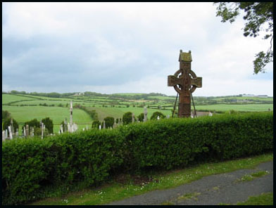
| Ardglass | Ardglass | 21: 55/37 | coastal town, townland and a parish name ; 8km SE of Downpatrick; click here for a photo and more information ;click here to see its location on a townland map ; means ' green height' | HCPCI p288 |
| Ardglass Arms Hotel | Ardglass | . | listed as a building 'at risk' in 1995; b/w photo available |
LM 1995 p13
|
| Ardglass Castle | Ardglass | . | set in 28 acres; built early 15th century as a warehouse; Lord Charles Fitzgerald bought it in 1790 and rebuilt it as a castle; sold to William Ogilvie in 1806;castle owned by Beauclerk family 28 Sep 1844 & Major Aubrey de Vere Beauclerk in 1852 & 1863; castles state 8 Nov 1851; improvements to castle 9 Dec 1876; Ardglass Golf Clubhouse since 1907; photo available |
DR; UJA; LWAG p 48,53; POD; GV; O'L V1 p 167; LM 1989
p52
|
| Ardglass | Kilmegan | 20: 32/42 | in Dromara Hills ;8km N of Castlewellan; means 'green height' | |
| Ardgowan | Down | . | in Downpatrick; residence of James Watterson in 1894 & R.L. Morrow in 1910 |
PPNZ; POD
|
|
Ardigoa |
Killyleagh | 21: 49/53 | a townland 3km W of Killyleagh;483 acres; click here to see its location on a townland map; ploughing match 6 Mar 1841; alleged child murder 1 Apr 1882 | DR |
| Ardigon House | Killyleagh | 21: 49/53 | on Dibney River 3km W of Killyleagh: a poem about the master 12 Jun 1875; residence of Robert Heron Esq.- death notice 23 Sep 1876 |
DR
|
| Ardilea | Loughinisland | 21: 41/40 | a townland just S of Clough village; click here to see its location on a map; 279 acres; was a McCartan stronghold in 1600; owned by Arthur Annesley then sold to David Ker family in 1786 ; the population in 1841 was 85& in 1851 65& in 1861 46 people |
JML (PRONI-D 1255/3/23); MO 8/11/04; DR* 3/12/03 ;
HCDTD p40
|
| Ardilea Bridge | Loughinisland | 21: 41/39 | over a stream; just near Inner Dundrum Bay | . |
| Ardilea House | Loughinisland | . |
1 km S of Clough; residence of Rev. William Annesley in 1846 & Mrs James in 1910 |
old b/w map L 14; POD |
| Ardkeen Ardkin |
Ardkeen | 21; 60/57 | a village and a parish; 6km N of Portaferry; 461 acres; click here to see its location on a townland map; means ' pleasant height'; Ardkeen Castle overrun by Sahne O'Nial in 1561; in 1659 there were 11 English/ Scots & 9 Catholic families here & the proprietors were John & James Savage Esqs.; mainly fishermen's huts; 33 thatched houses; 1 woollen draper, 2 grocers, 3 publicans, 1 tailor, 2 nailers, 5 shopkeepers; the streets were narrow & dirty and the houses ill kept by the landlord, a farmer who lives in the village; corn mill and a windmill in 1836; school built in 1832; Downpatrick Poor Law Union soup kitchen 13 Feb 1837;Poor Law District population was 2455 in 30 Nov 1839; public politcal meeting of all inhabitants 2 Jan 1797 (NS); Sabbath school 14 Aug 1841: soup kitchen 13 Feb 1847; Board of Guardians re graveyard 24 Aug 1872 (DR) | O'L V1 p 421 ; V7 1-3 OSM; SP; NS; DR; DR*; PNNI V2 p 9; JUAHS p14; LR 2015 p69 (drawing of castle site & church) |
|
Ardkeeragh |
Donaghmore | 29: 13/35 | 7km NW of Rathfriland; 275 acres; click here to see its location on a townland map; means ' hill of the sheep'; 16 acres is worn out bog; originally owned by Magennis clan | V3 p8 OSM; PNNI V1 p 90 |
| Ardkighan | Ballyphilip | . | alternate spelling for Ardgeehan townland in 1659 census |
PNNI V2 p 42
|
| Ardley River | Kilkeel | 29: 30/23 | small river in The Mournes, runs into Silent Valley |
PNNI V3 p 174
|
| Ardlussa | Bangor | . | villa in Princetown Rd , Bangor ; residence of Miss Ferrie in 1901 |
POD
|
| Ardmacaisse Ardmocosse |
Slanes | . | alternate name for Slanes parish in 1306; name of a burying ground & chapel; forfeited by John Fitznicholas in 1320; the parson in 1386 was John Hore then William Nangle then Robert Notyngham & John McGyan in 1594 | O'L V1 p 416,417; PNNI V2 p 115 ; LM 1994 p58 (map) |
| Ardmaine | Newry | . | on Fullerton Rd, Newry; residence of local Catholic bishops 1903-1932 | DDPPp3 |
| Ardmally River | Kilkeel | . | alternate name for Ardley River | PNNI V3 p 174 |
| Ardmara | Bangor | . | villa in Bangor ; built in 1860; residence of J. R. Garratt in 1901 |
OS map 1902 2.06; POD
|
| Ardmeen | Down | . | 2km E of Downpatrick; 239 acres; click here to see its location on a townland map; owned by Earl of Ardglass & leased to Thomas Beverley who sublet to John Maffet Nov 1669; owned by heirs of Lord De Clifford & Charles Leslie; proprietor Colonel Leslie of Glasslough in 1836 ; dry soil; County Assizes re roads & hill 26 Mar 1859 | LM 1985 p52; V17 p 52,57 OSM; DR |
|
Ardmenan |
Slanes & Ballyphilip | . | a village and townland; 2km S of Cloghy village; 143 acres; means ' height of the lid goats'; proprietor in 1836 was Mr Haistings; click here to see its location on a townland map ; school erected in 1826 | V7 p3, 8 & V17 p125 OSM; PNNI V2 p 116 |
| Ardmere | Down | . | farm; just outside Downpatrick on the Saul road | old b/w map O14 |
| Ardmillan | Slanes | . | alternate spelling for Ardminnan townland | V7 p 3 OSM |
| Ardmillan | Tullynakill | 21: 50/63 | a village in Ballymartin townland ; 2km N of Killinchy; means ' height of the little knoll; on the western shore of Strangford Lough; click here to see its location on a townland map; Bishops lands £140 in 1744; near Ardmillan Bridge is an ancient standing stone 9 by 6 feet; purchased by Mr. Murland of Castlewellan c. 1850; valuable lands & premises 27 Dec 1879; Caughey Estate, valuable lands for sale 10 Jan 1880 | V7 p90 OSM: DR; O'L V1 p 368, 369 & B p 32 |
| Ardmore Cottage | Bangor | . | between Bangor & Ballyholme Bays ; residence of Joseph W. McKee & J. Neill in 1901 | OS map 1901 2.06 ; POD |
| Ardmore | Comber | . | in Ballygowan; residence of J.H. Dickson Esq in 1910 & Senator J. Hill Dickson in 1938 |
POD; DR* 13/7/38
|
| Ardmore | Down | . | residence & grounds with Lodge entrance off Saul St, Downpatrick in 1901 |
OSM map
|
| Ardmore Terrace | Holywood | . | row of 8houses in Ballykeel townland;owned by John Simms in 1863 |
GV
|
| Ardmore | Seapatrick | . | near Banbridge; residence of Mrs. Hillis 29 Jul 1918 |
AEVB
|
| Ardnabannon House | Kilmegan | 29: 36/37 |
large Victorian two-storey house of pale buff brick ; 2km NE of Castlewellan on the Clough road; built for Charles Murland & designed by Thomes Turner in 1868 & completed c. 1870; residence of C. W. Murland in 1893 & James Murland until 1942; the U lster Weaving bought Ardnabannon with sixty acres of land and Sir Graham Larmor & his family lived there to 1950s; b/w photo available; now called Ardnabannon Outdoor Education Centre since late 1850s |
BWN; MO 23/1/2008 p4; DR 23/2/1939R;
LM 1997 cover,12,13
|
| Adnagale | Down | . | in Downpatrick; residence of Dr. James J. Murray in 1938 |
Irish Independent
|
| Ardnagreena | Holywood | . | in Circular Rd, Strandtown; residence of Charles W. Black in 1901 |
POD
|
| Ardnagreena | Knockbreda | . | in Knock Rd, East Belfast; residence of W.J. Farrell in 1902 |
POD
|
| Ardnalea House | Holywood | . | house & farm of 24 acres ; in Craigavad townland; 3km NE of Holywood town on Belfast Lough; leased by Lady Bateson in 1863 from William S. Mitchell ; marriage of Augustin Ross Esq., Ardnalea, to Harriet Ross of Bladensburgh 17 May 1873 at Rostrevor | old b/w map T5; GV ; DR |
| Ardnalea | Knockbreda | . | in Hawthornden Rd, Knock; residence of G.P.Gardner in 1902 |
POD
|
| Ardough | Kilcoo | . | alternate spelling for Ardaghy townland in 1659 census | PNNI V3 p 104 |
| Ardquin | Ardquin | 21: 58/55 | a townland of 190 acres & a parish; 3km NNW of Portaferry; the whole parish only has 3643 acres; click here to see its location on a townland map; means ' Conn's height'; Ardquin Castle was the home of the ancient Savage family; in 1659 there were 17 English/ Scots & 15 Catholic families here & the proprietor was Robert Ward Esq.;Bishops lands £100 in 1744; the proprietor in 1795 was the Rector of Dioces of Down; parish boundaries changed 22 Dec 1827; proprietor Mr Echlin in 1836; kelp; bazaar to raise funds to renovate National School 22 Sep 1877; old abbey here | NCT; V17 p118,127 OSM & V 7 p4, 89 OSM;SP; DR; old b/w map T15; UJA; O'L B p 153, 209, 319; PNNI V2 p 27 |
|
Ards |
. | . | a strip of land with Strangford Lough in the western side & the Irish Sea on the right; Newtownards & Donaghadee parishes are in the north & Portaferry in the south | . |
|
Ardtana |
Dromara | 20: 26/50 | a townland 3km W of Dromara ;627 acres: click here to see its location on a townland map; means high mound or rampart; Presbyterian church here ; school here in 1836 | V12 p63, 64, 65 OSM:BH; S P; LCB p 81 |
| Ardtanagh Artana |
Loughinisland | 20: 38/44 | a townland of 477 acres; Seaforde area ;means high open space; click here to see its location on a map;in 1659 there were 12 English/Scots & 6 Catholic families here ; the population in 1841 was 279 & in 1851 188 & in 1861 146 people | LCB p 81; TCC p33; HCDTD p38,40 |
| Ardtole | Ardglass | 21: 56/38 | a townland 1km NE of Ardglass; click here to see its location on a townland map; hills: old St Johns church here : there were 9 families needing famine relief here in 1847; bathing residence to let 12 May 1849; owned mainly by Aubrey de Vere Beauclerk in 1863 | V17 p 7,9 OSM; DR; O'L B p 322; FCD S2 p 25; GV |
| Ardtullagh | Holywood | . | a house ; residence of Clark family then Holywood Golf Club;b/w photo available |
NDM p139; Q4/7 CBSA
|
| Ardvara | Bangor | . | villa in Princetown Rd, Bangor; residence of W. Blackstock in 1901 | POD |
| Ardview House | Killinchy | 21: 50/60 | farm estate; 2km SE of Killinchy on Killyleagh road; hilly area; the proprietor in 1795 was Thomas Potter; furniture etc. for sale, 10 Sep 1853; residence of Robert Potter Esq. J.P.- death notice 25 Mar 1876; agrarian outrage- residence of Thomas Potter Miller 10 Jan 1880 & Miss Miller in 1910 & Mrs Grove Raines in 1926 | UJA;V7 p86 OSM: DR; POD; DR*28/2/1926 |
| Ardville | Donaghadee | . | residence of Arthur Hughes de WiNd in 1873 |
CR
|
|
Ardville
|
Holywood
|
.
|
house & 6 acres in Ballycultra townland; leased
by James Lemon in 1863 from rep. Robert S. Kennedy; with 10 acres, owned
by James Barbour in 1876 & 1886; residence of Mrs. Reilly in 1898
|
GV ; LOI; POD; AEVB
|
| Ardwhin | Ardquin | . | alternate spelling for Ardquin in 1659 census |
PNNI V2 p 29
|
| Arlington | Kilcoo | . | in Newcastle; residence of J.W. Alexander & Mrs Dickson in 1910 & Mrs J.W. Alexander in 1922 |
POD/ PTTF p7
|
| Armagh House | Knockbreda | . | a hotel 1-3 Albertsbridge Rd, East Belfast; proprietor in 1902 was Joseph Smyth |
POD
|
| Armitage Place | Kilcoo | . | residence in Newcastle in 1910; opposite the sea wall; next to Rowallane House; residence of Misses Alexander in 1922 |
NWAG p 59; POD/PTTF p7
|
| Armour's Hole | Kilkeel | . | a long cavity, extremely narrow, the waves beat in with fury at the bottom; to this place a son (James) requested his father (Edward Armor) to proceed by and refresh themselves; they were driving cattle for shipping; having left them at the side of the road they retired to this place, the son assuring the father that the hole was worth seeing; told him to lie on his stomach, so he might see it to perfection; as soon as the father did so, the son pushed him down; there are several red rocks to be seen which is said to be the blood of the father; the body floated to Newcastle where it was discovered before the son arrived there; another version says that James was enamoured of Mary O'Hagan but his father forbade the marriage so he killed him ;Mary died just after James was exectuted c. 1744 |
V3 p47,48 OSM; PNNI V3 p 55
|
| Armstrong Bridge | Magheradrool | 20: 34/54 | over Ballynahinch river ;2km W of Ballynahinch | . |
| Armstrongs Inn | Magheradrool | . | in Ballynahinch; Rev. Steel Dickson arrested here after 1798 Rebellion |
PE
|
| Arno's Vale | Kilbroney | 29: 16/19 | farm, on Carlingford Lough ;in Moygannon townland north of the road to Warrenpoint; built by Rev. McArthur then rebuilt by John Darley then owned by James Moore in 1795 & 1815; had a bathing lodge in 1836; residence of William F. Carter Esq.in 1846; owned by Robert McBlain in 1875 |
UJA;V3 p35 OSM ; NWB; PNNI
V1 p 156
|
| Aroan Isle | Ardkeen | . | alternate name for Inisharoan Island in 1744 | PNNI V2 p 20 |
| Arrandoon | Bangor | . | villa in Kinnegar ; residence of John McKee in 1901 |
POD
|
|
Arrochyne |
Ardkeen | . | ancient name for Ardkeen parish | LR 2005 p17 |
| Ardalgan | Saintfield | . | ancient townland; in 1659 there were 4 English/Scots & 1 Catholic family living here (could be Ardigon) | SP: SHM '94 p55 |
|
Artana |
Dromara or
Loughinisland |
. | see Ardtanagh | . |
| Arther's Hotel | Donaghadee | . | in Shore St, Donaghadee; proprietor in 1852 was William Arthur |
POD
|
| Arthgothin | Ballyphilip | . | place name mentioned in 1183; could be Ardgeehan twonaldn or could be in Ballee parish |
PNNI V2 p 42
|
| Arkinstown | Kilmore | . | farm; 2km E of Crossgar |
old b/w mapP12
|
| Armstrong's Bridge | Magheradrool | . | over a stream; 2km NW of Ballynahinch on the Hillsborough road |
old b/w map M8
|
| Arrandoon | Bangor | . | villa in Kinnegar ; residence of Thomas Duggan in 1901 |
POD
|
| Arthurs Hotel | Donaghadee | . | in Shore St, Donaghadee; the proprietor in 1846 was William Arthur |
POD
|
| Arthurs Port | Kilkeel | 29: 38/20 | small inlet in the Irish Sea, 1km N of Annalong | . |
| Articone | Ardkeen | . | at the southern end of Ardkeen parish |
V7 p3 OSM
|
| Arumah | Bangor |
.
|
villa in Princetown Rd, Bangor; residence of David
Turtlein 1901
|
POD |
| Ashbourn Villa | Knockbreda | . | in Ravenhill Road, Belfast; residence of Thomas Blaxham in 1902 |
POD
|
| Ashburn Cottage | Holywood | . | in Palmerston Road; residence of Joseph Gregg in 1902 |
POD; ACS p11 (map)
|
| Ashdene | Comber | 21: 46/68 | 1km SE of Comber, village; residence of George P. Culverwell in 1912 |
POD
|
| Ashfarm | Kilkeel | . | near Annalong; residence of James Purdy in 1910 |
POD
|
| Ashfield | Annahilt | 20: 31/56 | farm; near Carricknadarriff townland | . |
| Ashfield House | Dromore | 20: 16/51 | farm; in Edentiroory/Balleny townland; residence of James Allen Cowdy c. 1792 & Maurice Lindsay in 1815; David Lindsay Esq. in 1842 1846, George Black in 1847; owned by Maurice Lindsay in 1876 with 140 acres; residence of J Prenter in 1886 & William Alderdice c. 1900 & Misses Moore in 1910 & John & David McCrum in 1929 |
FP; BU 30/9/1842;LOI; MIs; POD;
Irish Gleanings
|
| Ashfield | Hillsborough | 20: 21/62 | farm; 3km NW of Hillsborough | . |
| Ashfield | Holywood | 15: 43/80 | in Holywood Rd, Knocknagoney townland; residence of the Bishop of Down & Connor; the palace was handsome though not large with a little planting around it in 1836; residence of William McKittrick in 1852 & William T. Pollock in 1902 |
V7 p 82 OSM ; POD
|
| Ashfield Cottage | Holywood | . | at 397 Holywood Rd, Holywood ; an old coaching station with two semi detached houses; residence of James Agnew in 1902; a guest house in 1955 |
POD ; ACS p11 (map) 69, 75 (photo)
|
| Ashfield Dairy | Holywood | . | near Sydenham; operated by the Agnew family early 1900s |
ACS p69
|
| Ashfield House | Holywood | . | a large house at 395 Holywood Rd, Holywood; residence of William T. Pollock in 1901; the Agnew family moved here from Ashfield Cottage in 1927;now demolished ; site of Ashfield High School |
ACS p11 (map), 69, 73 & 74 (photos)
|
| Ashfield House | Knockbreda | . | farm estate; on the eastern side of Ormeau demesne in Ravenhill Road ; 2km S of Ballymacarret ; residence of Miss Scott in 1902 |
V7 p 98 OSM ;OS map 1902 4.11
|
| Ashgrove | Knockbreda | . | house off Lisleen Road | P12/25 CBSA |
| Ashgrove House | Newry | . | house & farm of 44 acres in Drumcashelone townland ; 2km NE of Newry town; residence of William & Elizabeth Carlile in 1700 & Mr. Carlile in 1828; & Hugh Boyd (husband of Jane Carlile) c. 1830; leased by Isaac W.Dickinson in 1863 from Miss Carlisle; new foundation stone laid 26 Jun 1869; owned by Joshua M. Magee with 44 acres in 1876; residence of Mr. Michael J. Magee in 1902 & William & Isobella Mcbride in 1917 |
NCT; DR;GV; MIs; old b/w map B9; LOI; Irish World NY;
CWGC
|
| Ash Hill | Drumbo | 20: 33/64 | farm; 2km SE of Drumbo | . |
| Ashlea | Newtownards | 15: 52/76 | farm: 3km NE of Newtownards | . |
| Ashleigh House | Blaris | 20: 26/60 | farm; in Ravernet townland | . |
| Ashleigh House | Kilcoo | . | villa on the Bryansford Road; built c. 1854 ;described as a handsome late-Regency stuccoed two-storey house; residence of Rev William Randal Slacke, rector of St John's in 1854 & 1861; leased from Lord Annesley for £15.18.8 in 1854 for a term of 31 years or 3 lives but replaced by a new lease for 99 years in 1859 ; next tenant was Captain Rea & in 1877, Samuel Clarendon, a surgeon; residence of Mrs. Slacke in 1884 & Miss Grace Chane in 1910 |
NWAG p22; POD ;WDG p99
|
| Ashley Hall | Knockbreda | . | in Ballymacarrett; untenanted in 1852 |
POD
|
| Ashley House | Knockbreda | . | near Albertbridge Rd & Paulett Ave, East Belfast; residence of Dr. A. Moore in 1902 |
POD
|
| Ashley Lodge | Knockbreda | . | residence of John Johnston in 1833 & Agnes Scott in 1846 |
IIW # 34226/59000
|
| Ash Loanen | Bangor | . | an area near the Rectory |
Bangor p51
|
| Ashside | Drumbo | 20: 33/60 | farm; near Drennan townland | . |
| Ashside | Blaris | 20: 28/59 | farm; 4km E of Hillsborough | . |
| Ashton | Newry | . | residence of Capt. C.M. Seymour in 1824 |
POD
|
| Ash Tree (The) | Dromore | . | farm; 2km NE of Dromore town |
old b/w map J6
|
| Ashvale | Annahilt | . | farm; 4km SE of Annahilt village |
old b/w map M6
|
| Ashvale | Dromara | 20: 26/48 | farm; 2km SW of Dromara; residence of Henry Gregg in 1910 |
POD
|
| Ashvale | Killaney | . | farm; 2km NW of Saintfield town; residence of Joseph Edgar in 1856 |
old b/w map O8; Mis
|
| Ashvale Ashville |
Killinchy | 21: 50/59 | farm; 2km SE of Killinchy ; residence of Mrs. J.M. Anderson in 1886 & A.H. Hamilton & John Davidson in 1910 |
POD
|
| Ashville | Bangor | . | house at 33 Brunswick Rd, Bangor; residence of Mrs. Wilhelmina McDermott in 1915 | CWGC |
| Ashville | Holywood | . | large house & garden corner Larkfield Rd & Connsbrook Ave , Sydenham in 1904 | ACS p 11 (map) |
| Aspenville | Holywood | . | house & 2 acres in Holywood Rd corner Sydenham Rd , Strandtown ; next to Heyn Memorial Hall; leased by James Entwhistle in 1863 from Thomas McClure; residence of James Entwistle in 1902 & 1910 | GV ; POD ; ACS p49 (b/w photo) |
| Asphalte / Asphalto Cottage | Tullynakill | . | house & farm estate of 17 acres in Lisbane townland; leased by Rev. John McCaw in 1863 from William Ritchie ; residence of John & Agnes Minnis after they retired as teachers at Raffrey School; sometimes known as The Beeches |
GV; Hilary Gowdy
|
| Astolat | Knockbreda | . | residence of John Milliken c. 1890 | OS map 1901 5.09 |
| Astville | Killinchy | . | residence of Mr. W. W. Huston in 1915 |
CWGC
|
| Attical | Kilkeel | 29: 28/20 | a townland on the slopes of The Mournes, 6km NW of Kilkeel; 396 acres; click here to see its location on a map; means ' Catha's dwelling place; part of the Bagenal Estate in 1522 & owned by Lord Nicholas Bagenal in 1690s ; in 1659 there were12 Irish people living here & it was owned by Richard Houston Esq. |
SP; PNNI V3 p 10, 17; MO 6/8/2009
p6
|
| Auburn | Holywood | . | residence of John Harpur in 1898 |
PR
|
| Auburn | Knockbreda | . | in 91 Kings Rd, East Belfast; built c. 1890; residence of Henry McCulloch in 1902; now demolished |
POD; ACC p38
|
| Auburn Lodge | Kilkeel | . | 2km NE of Kilkeel town |
old b/w map E17
|
| Auburn Lodge | Tullylish | . | house, 50 acres, corn & flax mill for sale 27 Apr &1 Jun 1795 |
NS
|
| Auchrim | Kilkeel | . | alternate spelling for Aughrim townland in rent roll of 1688 |
PNNI V3 p 20
|
| Audleys Acre | Down | . | a townland 1km NE of Downpatrick; 8 acres; click here to see its location on a townland map; owner James Annesley in 1836; there were 8 houses; 4 families employed in agriculture & 2 in trade; 14 males & 14 females; 2 manufacturers; also known as Jordan's Acre;shipping casualty, schooner "Perseverance' ashore 5 Mar 1881 | V17 p52,57 OSM; DR |
| Audley's Castle | Ballyculter | 21: 57/51 | 15th century tower-house on the shores of Strangford Lough ;2 km NW of Strangford town; lands bought from Earl of Kildare; the first castle was wooden but was replaced by a stone castle ; owned by John Audley in 1558; passed from the Audley family to the Ward family (Bernard) in 1641/6 for £431; description of castle 9 Aug 1845: photo available |
V17 p 26 OSM : DR; LWAG p33:
HMNI p97 ; Inv 2006 p49; LR 2007 p10; LM 1986 p3-6; LR 2011 cover; Inv
2011 p22; MO 14/9/2016 p14 (photo)
|
| Audleys Roads | Ballyculter | 21: 58/51 | safe boating channel, 1km NW of Strangford town; 'Eagles Wing' washed ashore here in 1715 |
JUAHS p30
|
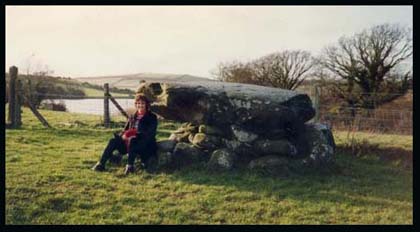
| Audleystown | Ballyculter | 21: 55/50 | a townland 3km W of Strangford town; lake; ancient chambered grave here ; corn mill; old castle here ; inhabited by Audley family up to early 1600s; owned by Lord Bangor in 1836; agrarian outrage 2 Mar 1850; up until 1852 there was a village with 25 families here but there were sent by the landlord to America onboard 'The Rose' ; horse racing held here in 1922; click here to see its location on a townland map | V17 p 25,26, 28, 30,31; LR 2005 p27; DR: HMNI p88; Inv 2011 p20,21; Inv 2011 p,26 |
| Aughaderrig | Aghaderg | . | old name for Aghaderg | V12 p1 OSM |
| Aughagallon | Blaris | . | see under Aghagallon | . |
| Aughdavanny | Seapatrick | . | a parcel of land inBallevy townland in 1618; on west bank of River Bann | PNNI V6 p 305 |
|
Aughintober Aughintubber |
Donaghmore | . | a townland 8km NNE of Newry; 227 acres with 18 acres of bog; click here to see its location on a townland map; means ' field of the well'; originally owned by Magennis clan; site of a celebrated spa well | V3 p7, 8, OSM; PNNI V1 p 90 |
| Aughioughel Aughiyochill | Kilkeel | . | alterante spellings for Aghyogill townland in rent roll of 1688 | PNNI V3 p 17 |
| Aughlish Cottages | Aghaderg | . | near Scarva; a row of weaver's cottages known as Potstick Row; there is also a townland in nearby Ballymore parish, Co. Armagh with this name | BCT p 23 |
| Aughlisnafin | Kilmegan |
29:36/39
|
a townland 4km NE of Castlewellan; 809 acres;click here to see its location on a townland map; Catholic church here;owned by Marquis of Downshire in 1863; malicious burnings 24 Apr 1875; Aughlisnafin Dramatic Society concert 5 Feb 1936 |
DR; GIC; DDW p 13; GV;
DR
|
| Aughly | Saintfield | . | alternate spelling for Oughley townland | POD |
| Aughlyoughal | Kilkeel | . | alternate spelling for Aghyoghill townland in 1809 | PNNI V3 p 17 |
| Aughnabrock | Loughinisland | . | means the badgers field | LCB p 81 |
| Aughnacavan | Donaghmore | . | a townland 7km NE of Newry; 143 acres ;click here to see its location on a townland map; means ' field of the hollows'; originally owned by Magennis clan; flax mill in 1836; Aughnacavan House here | V3 p8 OSM; old b/w map C8; PNNI V1 p 91 |
| Aughnacloy | Annaclone | 20: 19/43 | see Aghnacloy; near Bann river 8km E of Banbridge; | V12 p 18 OSM |
| Aughnacullion | Kilcoo | . | alternate spelling for Clonachillion townland |
KPCB
|
| Aughnadarragh | Killinchy | 21: 44/60 | a townland 4km E of Saintfield; 552 acres; click here to see its location on a townland map; large lough; Drumahay hill in this townland is 332 feet above sea level |
V7 p86 OSM : SHM '86 p32
|
| Aughnadrumman Aughnadrumma |
Moira | . | a townland 2km E of Moira town; 139 acres; click here to see its location on a townland map; means ' field of the ridge'; held by Sir Art Magennis in 1609; proprietor in 1795 was John berwick & Sir R. Bateson in 1836 | UJA;V12 p 120 OSM; PNNI V6 p 277, 278 |
| Aughnadunvarren | Hillsborough | 20: 23/56 | a townland 5km SW of Hillsborough; 613 acres; click here to see its location on a townland map; proprietor Lord Downshire; agent Mr Reilly in 1836; farms from 4-20 acres except Col. Corry's at 28 acres; rent on old leases 16 shillings & new leases 30 shillings an acre; good land; school; a list of charity subscribers from 1834 | V12 p85, 86, 99, 105 OSM |
| Aughnafosker | Moira | . | a townland 1km WSW of Moira town; 126 acres; ;just SW of Moira town; means ' Gilkosker's field'; originally belonged to the O'Laverty family; proprietor was Jasper Waring in 1795 & Sir R. Bateson in 1836 | UJA; V12 p118, 120 OSM; PNNI V6 p 278, 279 |
| Aughnagon Aughnagun Aghagun |
Clonallan | 29: 14/26 | a townland of 509 acres; 3km SW of Mayobridge village; near Derryleckagh Lough; click here to see its location on a townland map; means ' field of the smiths'; originally belonged to O'Garvey family then Hugh Magennnis then Edwrad Trevor by 1661; a Hedge School here c. 1800 | V3 p 61 OSM; PNNI V1 p 58, 59; DDPP p89 |
| Aughnahoory Aughnahury |
Kilkeel | . | a townland of 557 acres; click here to see its location on a map; means ' ford on the river Urach'; part of the Bagenal Estate in 1522 & owned by Lord Nicholas Bagenal in 1690s ; in 1659 there were 13 Irish people ling here & it was leased by Richard Houston Esq.; Orange Lodge #343B was formed in 25 Oct 1861 |
SP; PNNI V3 p 10, 18; MO 5/8/
2009 p6; HOTC p53; OKA p13
|
| Aughnaleck | Annahilt | . | a townland of 671 acres; click here to see its location on a map; means ' ford of the flagstones'; 68 families listed in census without surnames dated 1821, total inhabitants 411, 31 employed in agriculture, 19 in trade,16 servants, 12 weavers; school in 1836; proprietor Mr. Mussenden Esq. of Larchfield, agent Rev. Corner, Lisburn; 148 acres of this townland are in Larchfield demesne; 26 landholders; farms were from 1-32 acres; rent was £2.5.0 an acre; 12 weavers who work for Mr Crummey, Dromore; school established in 1830; | HMP; V12 p20, 23 OSM |
| Aughnaleck River | Kilkeel | 29: 25/22 | rises in the Mournes and runs south into Water Water river |
PNNI V3 p 175
|
| Aughnaloopy | Kilkeel | 29: 30/17 | a townland 3km NW of Kilkeel town; 382 acres; click here to see its location on a map; means ' field of the loop'; part of the Bagenal Estate in 1522 & owned by Lord Nicholas Bagenal in 1690s; ;in 1659 there were 8 Irish people living here & it was owned by Patrick Modder O'Howen Esq.; the Bagenal estate passed to Edward Bayly & Robert Nedham in 1713; the population in 1841 was 190 then in 1851 it was 215 & 217 in 1861 ( living in 38 houses ); Fiona Doyle Jones has written a comprehensive book on this townland called ' A Mourne Townland- A History & People of Aughnaloopy' (self published in 2012) |
SP; MO 5/8/2009 p6; PNNI V3 p10,
19; HPA p10, 47
|
| Aughnaskeagh | Dromara | 20: 25/48 | a townland 4km SW of Dromara; 693 acres; click here to see its location on a townland map; means ' field of whitethorn'; 2 mills in 1836; murder of John Rankin by William Hanna 17 Oct 1857 | V12 p 63, 65 OSM: DR |
| Aughnaskeagh House | Dromara | 20: 24/48 | farm; 4km WSW of Dromara | . |
| Aughnavallog | Drumballyroney | . | a townland 3km N of Rathfriland; 844 acres;means 'field of the swallows'; click here to see its location on a townland map; Covenanting Presbyterian meetings held here c. 1770; proprietor General Meade whose agent was Crane Brush Esq. of Rathfriland in 1836; two largest farms were 35 acres; rents were old leases 10-12 shillings an acre & new leases 21 shillings an acre; an island bog; Church of Ireland & glebe here; large stone in Fin McCool legend; school built | ASWT p6; V3 p10,13,14, 16,17, 18 OSM; GIC; PNNI V6 p 154 |
| Aughnavallog Cottage | Drumballyroney | 29: 21/36 | 3km NE of Rathfriland; | . |
| Aughnaveigh | Newry | . | alternate name for Altnaveigh townland in 1830 | PNNI V3 p 6 |
| Aughneskeagh | Dromara | . | see Aughnaskeagh | . |
| Aughnehoory/ Aughnihury | Kilkeel | . | alternate spelling for Aughnahoory townland in rent toll of 1688 & in 1792 |
PNNI V3 p 18
|
| Aughneluby | Kilkeel | . | alternate spelling for Aughnaloopy townland in rent roll of 1688 |
PNNI V3 p 19
|
| Aughnawhellian | Kilcoo | . | residence of John Maginn Mar 1839 |
PR
|
| Aughrim | Kilkeel | . | a townland of 670 acres; click here to see its location on a map; means ' horse ridge'; part of the Bagenal Estate in 1522 & owned by Lord Nicholas Bagenal in 1690s ; in 1659 there were 3 Irish people living here & it was owned by Richard Houston Esq. |
SP; PNNI V3 p 10, 19; MO 6/8/2009
p6
|
| Aughrim Hill | Kilkeel | 29: 28/18 | hill on the end of The Mournes, 4km NW of Kilkeel town | . |
| Aughrim River | Kilkeel | 29: 29/18 | rises on the slopes of the Mournes near Attical and runs S into the Irish Sea at Kilkeel town | . |
| Augustaville | Bangor | . | 60-62 Princetown Rd, Bangor; built by Robert Russell 1885/7; residence of Robert Russell & Charles Lepper in 1901 |
NDM p136; OS map 1902 2.05 ; POD
|
| Aunesvale | Kilmegan area | . | residence of Joseph Magenis in 1835 |
IIW V4 p103
|
| Aureen | Comber | . | in The Square, Comber; residence of John Miller ,distiller c. 1860; a cobbled, mosaic pavement is outside & depicts a hunting scene; click here for a photo |
SG; TOOC p75
|
| Australia House | Kilkeel | . | near Annalong; residence of Robert Hill in 1910 |
POD
|
| Ava Hotel | Bangor |
.
|
cnr Abbey St & Catherine Place, Bangor in 1902
|
OS map 2.05 |
| Avoca Lodge | Kilcoo | . | house in Newcastle; residence of William Beatty 1830- 1884 & Edmund Beatty J.P. in 1910 & 1922 | POD; WDG p12,13 |
| Avondale | Knockbreda | . | in Kings Rd, East Belfast; residence of J.H. Morrowin 1902 |
POD
|
| Avondale House | Rathmullan | . | in Ballylucas townland; residence of Robert Fitz in 1899 |
Irish World
|
| Avoneil House | Knockbreda | . | off Avoneil Rd, East Belfast; residence of Robert McKibbin in 1852; owned by Joseph Faren with 13 acres in 1876 |
OS map 1902 4.11 ; POD ; LOI
|
| Avonmore | Bangor | 15:56/80 | house & grounds ; in Ballyfotherly townland, Maxwell Road |
OS map 1902 2.05. |
| Avonmore | Knockbreda | . | a house in Kockbreda Road; residenc e of Herbert Shilliday in 1919 |
CR
|